
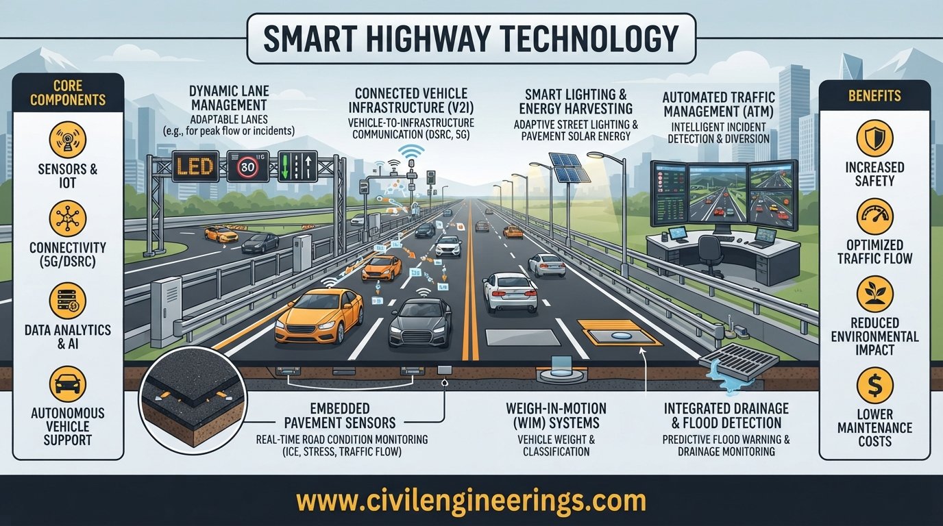
Modern highways are no longer limited to asphalt, concrete, bridges, signs, and drainage systems. As traffic volumes increase and transportation networks become more complex, road infrastructure must respond faster to changing conditions. This shift has created a new generation of intelligent infrastructure known as Smart Highway Technology.
Smart highways combine conventional highway engineering with sensors, communication networks, artificial intelligence, connected vehicles, automated traffic management, digital signs, weather monitoring, and real-time data analytics. The objective is not simply to add electronic devices to a road. A properly designed smart highway uses technology to understand what is happening on the network and support faster, safer, and more informed decisions.
For civil and highway engineers, this field connects geometric design, pavement engineering, traffic engineering, telecommunications, electrical systems, data science, and transportation planning. Technologies such as vehicle-to-everything (V2X) communication can allow vehicles and roadside infrastructure to exchange information about hazards, traffic, speed, work zones, and road conditions. (Department of Transportation)
This guide explains the engineering concept behind smart highways, their major technologies, applications, benefits, limitations, design considerations, standards, and practical implementation strategies.
What Is Smart Highway Technology?
Smart Highway Technology refers to the integrated use of digital, electronic, communication, sensing, and automation technologies to monitor, manage, and improve highway operations.
A conventional highway primarily provides physical transportation capacity. A smart highway adds an information and decision-making layer to that physical infrastructure.
The basic concept can be represented as:
Road Infrastructure → Sensors → Communication → Data Processing → Decision → Control/Warning → Road User Response
This creates a continuous feedback loop.
For example, a traffic monitoring system may detect that vehicle speeds have fallen sharply upstream of an incident. The control center can process the information, confirm the event using cameras or other sensors, and then activate variable message signs or speed-control measures.
The Institution of Civil Engineers describes smart motorways as systems that use technology and operational procedures to monitor and respond to changing traffic conditions. (Institution of Civil Engineers (ICE))
Smart highway systems can therefore be considered an advanced form of Intelligent Transportation Systems (ITS).
Smart Highway vs Conventional Highway
A conventional road generally depends on fixed signs, periodic inspections, manual traffic control, and scheduled maintenance.
A smart highway can add:
- Real-time traffic monitoring
- Automated incident detection
- Variable message signs
- Variable speed limits
- Road-weather information
- Connected vehicle communication
- AI-based traffic prediction
- Smart lighting
- Electronic tolling
- Predictive pavement maintenance
- Work-zone communication
- Emergency response integration
The difference is not that a smart highway replaces civil engineering. Instead, it extends civil engineering with digital intelligence.
Major Components of Smart Highway Technology


A successful smart highway depends on several technologies working as one coordinated system. Installing cameras or sensors independently does not make a highway intelligent.
Traffic Detection Sensors
Traffic sensors provide real-time information about vehicles and traffic flow.
Common technologies include:
- Inductive loop detectors
- Radar detectors
- Microwave sensors
- Video detection systems
- Infrared sensors
- Bluetooth or Wi-Fi-based travel-time detection
- Connected vehicle probe data
These systems can collect traffic volume, speed, occupancy, vehicle classification, travel time, and queue information.
For basic traffic flow analysis:
q = k × v
Where:
- q = traffic flow
- k = traffic density
- v = average traffic speed
Reliable traffic data allows engineers to identify congestion patterns and optimize highway operations.
CCTV and Computer Vision
Closed-circuit television cameras remain important components of intelligent highway management.
Modern systems can combine video cameras with computer vision to identify:
- Stopped vehicles
- Wrong-way driving
- Congestion
- Pedestrians
- Road debris
- Crashes
- Smoke or fire
- Lane obstructions
- Work-zone activity
Instead of relying entirely on a control-room operator to watch dozens of screens, computer vision can flag unusual events for human verification.
Variable Message Signs
Variable Message Signs, commonly called VMS or Dynamic Message Signs, provide changing information to drivers.
They can communicate:
- Congestion warnings
- Crash information
- Lane closures
- Weather warnings
- Travel times
- Detour information
- Speed restrictions
- Road-work alerts
Smart highways use these signs as an important link between the transportation management center and road users.
Variable Speed Limit Systems
Variable speed limits allow highway authorities to modify speed restrictions according to traffic, weather, incidents, or road conditions.
A simplified operating principle is:
Detection → Analysis → Recommended Speed → Sign Activation → Driver Response
The purpose is not simply to reduce speed. Proper speed harmonization can help manage traffic flow, protect the back of queues, and provide additional reaction time.
Smart motorway systems have used traffic detection, algorithms, variable mandatory speed limits, and stopped-vehicle detection to manage changing highway conditions. (Institution of Civil Engineers (ICE))
Vehicle-to-Everything Communication
V2X is one of the most important technologies associated with future smart highways.
It includes:
- V2V: Vehicle-to-Vehicle
- V2I: Vehicle-to-Infrastructure
- V2P: Vehicle-to-Pedestrian
- V2N: Vehicle-to-Network
Together, these are commonly described as Vehicle-to-Everything communication.
A connected vehicle can exchange information concerning position, speed, movement, hazards, and road conditions. This can provide situational awareness beyond what an individual vehicle’s onboard sensors can detect. (Department of Transportation)
Roadside Units
Roadside Units, or RSUs, act as communication points between infrastructure and connected vehicles.
An RSU may be installed near:
- Intersections
- Toll plazas
- Highway ramps
- Work zones
- Bridges
- Tunnels
- Incident-prone locations
The RSU can receive information from vehicles and infrastructure systems and transmit relevant warnings or operational data.
Road Weather Information Systems
Weather has a major influence on highway safety and pavement performance.
Road Weather Information Systems can monitor:
- Pavement temperature
- Air temperature
- Humidity
- Rainfall
- Snow or ice
- Visibility
- Wind
- Surface conditions
The resulting information can support weather warnings, maintenance decisions, speed management, and winter operations.
For regions affected by heavy rainfall, flooding, fog, dust storms, or extreme temperatures, road-weather monitoring can be particularly valuable.
Smart Lighting
Smart lighting systems use sensors and controls to adjust lighting according to:
- Traffic demand
- Time of day
- Weather
- Pedestrian activity
- Incidents
- Road-user presence
LED lighting combined with adaptive controls can reduce unnecessary energy consumption while maintaining required visibility.
Electronic Toll Collection
Electronic tolling removes or reduces the need for conventional cash-based toll transactions.
Technologies can include:
- RFID
- Automatic number plate recognition
- Account-based tolling
- Open-road tolling
- Digital payment systems
Smart tolling can improve traffic throughput and generate useful transportation data.
How Does a Smart Highway Work?
A smart highway can be understood as a five-layer engineering system.
Layer 1: Physical Infrastructure
This is the traditional highway system:
- Pavement
- Bridges
- Culverts
- Drainage
- Signs
- Guardrails
- Lighting
- Interchanges
- Lane markings
Technology must operate within this physical environment.
Layer 2: Sensing
Sensors collect information from the road and surrounding environment.
For example, radar may detect traffic speed while cameras verify an incident.
Layer 3: Communication
Collected data must travel to the appropriate processing system.
Communication infrastructure may include:
- Fiber-optic networks
- Cellular networks
- Wireless links
- Dedicated roadside communication
- V2X systems
Layer 4: Data Processing and Analytics
Raw data has limited value until it is interpreted.
A traffic management platform can combine information from multiple sources and identify patterns.
AI and machine-learning systems may help predict:
- Congestion
- Incident probability
- Travel-time changes
- Maintenance requirements
- Abnormal traffic conditions
Layer 5: Control and User Information
The final stage converts analysis into action.
Examples include:
- Changing a speed limit
- Activating a warning sign
- Dispatching an emergency team
- Closing a lane
- Updating traveler information
- Adjusting ramp metering
- Changing traffic signal timing
The most effective systems maintain a human-in-the-loop approach for safety-critical decisions.
Artificial Intelligence in Smart Highway Systems
Artificial intelligence is increasingly important because highway networks generate enormous amounts of data.
AI can analyze information from cameras, sensors, connected vehicles, weather stations, GPS systems, and historical traffic databases.
AI-Based Traffic Prediction
Instead of waiting for congestion to occur, predictive models can estimate future traffic conditions.
For example:
Predicted Traffic = f(Current Flow, Historical Pattern, Weather, Incidents, Events, Road Capacity)
This is not a universal engineering formula but a conceptual representation of the variables used in predictive models.
Traffic managers can use forecasts to implement control strategies before congestion becomes severe.
Automated Incident Detection
AI-based video analytics can identify unusual traffic behavior.
A sudden reduction in speed combined with stopped vehicles may indicate a crash or obstruction.
The system can then send an alert to the traffic management center.
Predictive Pavement Maintenance
Smart highway technology can also support pavement management.
Data from:
- Laser scanners
- Cameras
- Vehicle-mounted sensors
- Inertial measurement systems
- Pavement condition surveys
can help identify:
- Cracking
- Rutting
- Potholes
- Surface deformation
- Roughness
- Skid-related concerns
Instead of repairing every road section at the same time, agencies can prioritize interventions according to condition, traffic importance, risk, and predicted deterioration.
Smart Highway Technology for Road Safety
Safety is one of the strongest reasons to develop intelligent highway infrastructure.
Connected systems can provide early warnings for hazards that drivers may not immediately see.
Examples include:
- Rear-end collision warnings
- Wrong-way vehicle alerts
- Work-zone warnings
- Emergency vehicle alerts
- Queue warnings
- Road-weather warnings
- Reduced-speed warnings
- Pedestrian alerts
- Lane-change warnings
The U.S. Department of Transportation identifies numerous V2X safety and mobility applications, including emergency electronic brake-light warnings, forward collision warnings, work-zone advisories, road-weather alerts, wrong-way entry warnings, and emergency vehicle priority. (ITS Joint Program Office)
V2X is particularly useful because communication does not always depend on direct line of sight. A connected system can share information about hazards that may be outside a driver’s immediate visual field. (Department of Transportation)
Smart Highway Technology and Traffic Management
Highway capacity is not determined only by pavement width. Operational efficiency also depends on how effectively traffic is managed.
Smart traffic management may include:
- Ramp metering
- Dynamic lane management
- Variable speed limits
- Congestion monitoring
- Incident management
- Dynamic route guidance
- Adaptive traffic signals
- Travel-time information
- Managed lanes
The objective is to use existing infrastructure more efficiently.
This becomes increasingly important where widening a highway is expensive or physically constrained.
Smart Work Zones
Road construction and maintenance create temporary hazards.
Connected work-zone technology can provide real-time information about:
- Lane closures
- Worker locations
- Temporary speed limits
- Construction vehicles
- Queue formation
- Detours
- Changing traffic patterns
The Federal Highway Administration’s connected-corridor initiatives emphasize standardized data exchange for work zones, incidents, weather alerts, and special events. Such data sharing can help agencies coordinate transportation decisions more rapidly. (Federal Highway Administration)
For contractors, this means smart highway construction is not only about completing physical works. It also involves managing digital information associated with temporary traffic arrangements.
Smart Highway Technology for Emergency Management
A highway incident can quickly develop into secondary congestion or additional crashes.

A smart system can support emergency response through:
- Automatic incident detection
- Control-center verification
- Immediate traveler warning
- Lane or speed management
- Emergency vehicle dispatch
- Route optimization
- Continuous incident monitoring
- Recovery and reopening
Connected vehicle systems can also support emergency vehicle priority and alerts.
This integrated approach can reduce the time between incident detection and response.
Benefits of Smart Highway Technology
The main advantages include:
Improved Safety
Real-time warnings and faster incident detection can reduce exposure to hazards.
Better Traffic Flow
Dynamic traffic management helps authorities respond to changing demand rather than relying only on fixed operating plans.
Reduced Congestion
Information systems can help detect and manage queues before they spread.
Faster Incident Response
Automated alerts can reduce detection time and improve coordination.
Better Asset Management
Continuous data collection supports evidence-based maintenance planning.
Lower Environmental Impact
Smoother traffic and reduced unnecessary idling can contribute to lower fuel consumption and emissions. ITS technologies can also reduce unnecessary travel and improve transportation efficiency. (ISO)
Improved Traveler Information
Drivers receive more useful information about road conditions, incidents, travel times, and restrictions.
Better Use of Existing Infrastructure
Smart technology can increase operational efficiency without immediately requiring major highway widening.
Challenges and Limitations
Smart highways also introduce significant engineering and management challenges.
High Initial Investment
Sensors, communication networks, cameras, control centers, power systems, and software require substantial capital.
Maintenance Requirements
Electronic equipment needs inspection, calibration, replacement, cybersecurity management, and reliable power.
Data Quality
Poor-quality sensor data can produce poor decisions.
Engineers should establish:
- Calibration procedures
- Data validation
- Redundancy
- Fault detection
- Quality-control protocols
Cybersecurity
A connected highway is a digital infrastructure system. Cybersecurity must therefore become part of highway engineering rather than an afterthought.
Potential risks include unauthorized access, communication disruption, data manipulation, and system outages.
Interoperability
Different suppliers and agencies must be able to exchange data.
The USDOT emphasizes interoperability as a fundamental requirement for reliable V2X deployment. (ITS Joint Program Office)
Public Acceptance
Road users must understand how smart highway systems work.
Technology that changes speed limits, lane availability, or road operations requires clear communication and appropriate driver education.
Engineering Design Considerations for Smart Highways
Smart technology should be incorporated during highway planning rather than added after construction whenever practical.
Corridor Assessment
Engineers should first determine:
- Traffic demand
- Crash history
- Existing ITS infrastructure
- Communication coverage
- Weather risks
- Incident frequency
- Road geometry
- Utility availability
- Power requirements
- Future technology needs
Sensor Location
Sensor placement should reflect engineering objectives.
For traffic monitoring, engineers should consider:
- Interchange spacing
- Merge and diverge areas
- Known congestion points
- Incident-prone locations
- Horizontal and vertical geometry
- Sight distance
- Environmental conditions
Power and Communication
Every field device needs dependable power and communication.
Design should consider:
- Utility power
- Solar systems where appropriate
- Battery backup
- Fiber-optic networks
- Wireless communications
- Network redundancy
Data Architecture
A smart highway should have a clear data architecture.
A typical arrangement is:
Field Device → Edge Processing → Communication Network → Traffic Management Center → Analytics → Operational Response
Edge computing can process certain information close to the field device, reducing unnecessary communication delays.
Smart Highway Technology Standards and Engineering References

Smart highway projects should follow applicable national standards, transportation-agency requirements, communication standards, electrical codes, and road design manuals.
Depending on the project location, engineers may consult:
- AASHTO guidance for highway design, transportation infrastructure, roadside systems, and traffic-related engineering.
- IRC standards and guidelines for road geometry, traffic management, road safety, pavement, signs, markings, and related highway infrastructure in India.
- ICE technical knowledge and professional guidance concerning highways, transportation systems, digital infrastructure, and intelligent transport systems.
- FHWA and USDOT publications for connected vehicles, V2X, ITS, traffic management, and connected corridors.
- Relevant ISO and other international standards for intelligent transportation systems, information exchange, communications, and system interoperability.
Standards should never be treated as a substitute for engineering judgment. The applicable edition, jurisdictional requirements, project specifications, and authority approvals should always be checked before design or construction.
Practical Example of a Smart Highway
Consider a six-lane highway experiencing recurring peak-hour congestion.
A smart highway strategy could include:
- Radar traffic detectors every selected interval
- CCTV cameras near interchanges
- Road-weather stations
- Variable message signs
- Variable speed-limit signs
- Fiber-optic communication
- Traffic management center
- Connected vehicle roadside units
Suppose an accident blocks one lane.
The detection system observes an abnormal reduction in speed. A camera verifies the incident. The traffic management center receives the alert and activates an upstream warning.
The system may then:
- Display an incident warning.
- Reduce the upstream speed limit where appropriate.
- Warn connected vehicles.
- Notify emergency responders.
- Provide alternate-route information.
- Monitor queue development.
- Adjust traffic-management measures as conditions change.
- Restore normal operation after the incident is cleared.
This illustrates the fundamental principle of a smart highway: sense, analyze, decide, communicate, and respond.
Recommendations for Civil Engineering Students
Students should understand both traditional highway engineering and digital transportation systems.
Focus on:
- Traffic flow theory
- Highway geometric design
- Pavement engineering
- Transportation planning
- GIS
- Data analysis
- Basic programming
- IoT concepts
- Sensors
- V2X communication
- Intelligent Transportation Systems
A useful academic project could involve collecting traffic data and developing a simple congestion prediction model.
The strongest highway engineers of the future will understand how physical infrastructure interacts with digital systems.
Recommendations for Highway Engineers and Consultants
Engineers should avoid selecting technology simply because it is new.
Start with the transportation problem.
Ask:
What problem are we trying to solve?
Then determine whether sensors, V2X, AI, dynamic signs, adaptive control, or another technology can provide a measurable improvement.
Engineers should also establish performance indicators such as:
- Incident detection time
- Travel-time reliability
- Average delay
- Queue length
- Crash frequency
- System availability
- Sensor accuracy
- Response time
- Maintenance cost
Technology should be evaluated according to measurable outcomes rather than marketing claims.
Recommendations for Contractors
Contractors have an important role in successful smart highway implementation.
Pay particular attention to:
- Duct and conduit installation
- Fiber-optic protection
- Equipment foundations
- Cable routing
- Earthing and electrical protection
- Sensor mounting
- Camera sight lines
- Waterproofing
- Equipment commissioning
- Testing and integration
- As-built documentation
Construction teams should coordinate civil, electrical, communications, ITS, and traffic-management works from the beginning.
A poorly installed cable duct or incorrectly positioned camera can compromise an otherwise sophisticated system.
Future of Smart Highway Technology
The future will move toward greater integration between highways, vehicles, cities, logistics systems, and energy networks.
Emerging areas include:
- Cooperative automated driving
- AI-powered traffic control
- Digital twins
- Predictive infrastructure management
- Connected autonomous vehicles
- Advanced V2X networks
- Smart electric-vehicle charging
- Drone-based inspection
- Automated pavement condition assessment
- Cloud-based transportation management
- Edge computing
- Real-time road-weather intelligence
The important trend is convergence. Highway infrastructure will increasingly become part of a larger digital transportation ecosystem.
The FHWA’s connected-corridor work already emphasizes standardized information exchange for incidents, work zones, weather, and events, creating a foundation for broader automation and AI applications. (Federal Highway Administration)
Frequently Asked Questions About Smart Highway Technology
1. What is Smart Highway Technology?
Smart Highway Technology is the integration of sensors, communication networks, AI, connected vehicles, intelligent traffic management, and digital infrastructure into highway systems to improve safety, mobility, efficiency, and asset management.
2. What is the difference between a smart highway and a normal highway?
A conventional highway mainly provides physical transportation infrastructure. A smart highway adds real-time sensing, communication, data analysis, and automated or assisted operational control.
3. What technologies are used in smart highways?
Common technologies include CCTV, radar sensors, inductive loops, VMS, variable speed limits, V2X communication, roadside units, road-weather stations, AI analytics, electronic tolling, smart lighting, and traffic management systems.
4. How does V2X improve highway safety?
V2X allows vehicles to exchange information with other vehicles, roadside infrastructure, pedestrians, and networks. This can provide warnings about hazards, work zones, emergency vehicles, road conditions, and traffic events. (ITS Deployment Evaluation)
5. Can AI be used for highway maintenance?
Yes. AI and computer vision can help identify pavement defects, analyze inspection data, predict deterioration, prioritize maintenance, and support asset-management decisions.
6. Are smart highways expensive?
Initial costs can be significant because smart highways require sensors, communications, power, software, control centers, and maintenance. However, lifecycle benefits can justify investment where technology produces measurable improvements in safety, congestion management, reliability, and maintenance.
7. What is the role of civil engineers in smart highways?
Civil engineers remain responsible for the physical infrastructure and must coordinate geometry, pavement, drainage, structures, traffic operations, roadside equipment, utilities, construction, and technology systems.
8. Are smart highways suitable for developing countries?
Yes, but implementation should be based on local needs, available budgets, communication infrastructure, maintenance capacity, traffic conditions, and technical skills. A phased approach is often more practical than attempting to digitize an entire highway network at once.
9. What standards are used for smart highway projects?
Applicable requirements may include AASHTO, IRC, FHWA/USDOT guidance, ICE professional resources, ISO standards, electrical codes, ITS specifications, communication standards, and project-specific requirements. The governing authority and current applicable editions should always be verified.
10. What is the future of smart highways?
Future highways are expected to become increasingly connected, predictive, automated, and data-driven. Integration among V2X, AI, autonomous vehicles, digital twins, smart maintenance, and intelligent traffic management will be a major direction of highway development.
Conclusion
Smart Highway Technology represents a major evolution in the way transportation infrastructure is planned, constructed, operated, and maintained. The modern highway is becoming more than a paved corridor; it is developing into an interconnected system capable of sensing conditions, exchanging information, analyzing data, and supporting rapid operational decisions.
For civil engineers, this transformation does not reduce the importance of traditional highway engineering. Instead, it expands the profession. Pavement design, geometric design, drainage, structures, traffic engineering, road safety, construction management, and maintenance must increasingly work together with sensors, communications, AI, and connected vehicles.
The most successful smart highway projects will not necessarily be those with the largest number of sensors or the newest software. They will be projects where technology solves clearly defined transportation problems, operates reliably, remains maintainable, protects data, and delivers measurable improvements.
For students and professionals, learning smart highway systems today can provide a strong foundation for the next generation of intelligent transportation infrastructure.

Kamran Malik is a passionate civil engineering writer and researcher who specializes in construction, transportation, structural engineering, and infrastructure topics. Through his articles on CivilEngineerings.com, he simplifies complex engineering concepts and shares practical insights, industry trends, and educational resources for students, professionals, and engineering enthusiasts.