
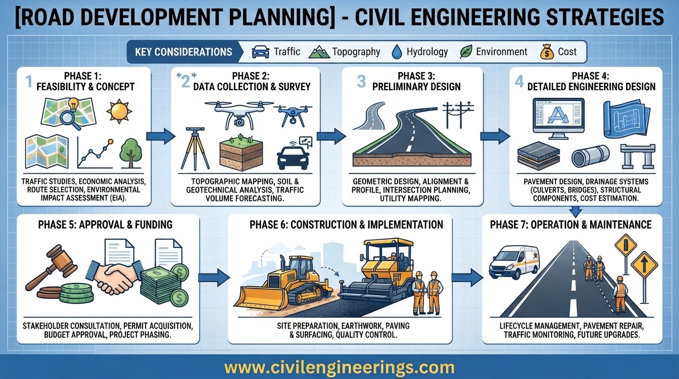
Roads do far more than connect two locations. A well-planned road network supports economic growth, improves access to education and healthcare, reduces travel time, connects production areas with markets, and strengthens regional development. When road projects are planned without understanding future traffic, land use, population growth, environmental constraints, and available funding, expensive infrastructure can quickly become inefficient or inadequate.
Road Development Planning is the systematic process of identifying transportation needs, assessing existing infrastructure, forecasting future demand, selecting suitable corridors, evaluating alternatives, prioritizing investments, and preparing projects for implementation. It connects transportation policy with practical highway and road construction decisions.
For civil engineering students, highway engineers, consultants, government agencies, and contractors, understanding this process is essential. A good plan does not simply ask, “Where should we build a road?” It asks, “What transportation problem are we solving, who will use the facility, what will demand look like in the future, and what solution provides the best long-term value?”
This guide explains the complete planning process, from network assessment and traffic forecasting to corridor selection, economic evaluation, environmental considerations, project prioritization, implementation, and monitoring.
What Is Road Development Planning?
Road Development Planning is the structured process used to determine how a road network should be improved, expanded, maintained, or developed to meet present and future transportation requirements.
It normally considers:
- Existing road network conditions
- Population and demographic growth
- Traffic demand and travel patterns
- Land-use development
- Freight and commercial movement
- Road safety
- Public transportation
- Environmental constraints
- Right-of-way requirements
- Construction and maintenance costs
- Economic development objectives
- Available government or private funding
The planning process operates at several levels. A national highway development program may identify strategic corridors between major economic centers, while a provincial or regional plan may focus on intercity connectivity. At the urban level, planning can involve arterial roads, collectors, local streets, intersections, pedestrian facilities, public transport corridors, and traffic management.
A strong road development plan therefore works as a bridge between transportation planning, land-use planning, highway engineering, pavement engineering, traffic engineering, environmental planning, and infrastructure investment.
Why Road Development Planning Is Important
Poor planning can produce roads that look impressive immediately after construction but fail to solve the underlying transportation problem.
For example, widening a road may increase capacity for a short period. However, if uncontrolled development continues along the corridor, access points multiply, pedestrian activity increases, and traffic demand grows, congestion may return quickly.
Good planning considers the complete transportation system rather than treating every road as an isolated project.
Supporting Economic Development
Road connectivity reduces the time and cost required to move people and goods. Better connections can improve access to markets, industrial zones, agricultural areas, ports, airports, and logistics centers.
A strategically selected highway can therefore produce benefits beyond transportation itself.
Improving Accessibility
Road development should provide reasonable access to communities, schools, hospitals, employment centers, commercial areas, and emergency services.
This is particularly important in rural regions where poor connectivity can limit economic and social opportunities.
Managing Future Traffic Demand
Traffic volumes rarely remain constant. Population growth, vehicle ownership, industrial development, tourism, and changes in land use can significantly alter travel demand.
Road development planning attempts to anticipate these changes instead of reacting after congestion has already become severe.
Improving Road Safety
Planning provides an opportunity to address safety before construction begins.
Engineers can evaluate:
- Intersection spacing
- Road hierarchy
- Access control
- Horizontal and vertical alignment
- Pedestrian crossings
- Bicycle facilities
- Roadside hazards
- Median arrangements
- Speed management
- Sight distance
Optimizing Infrastructure Investment
Governments and infrastructure agencies usually face limited budgets. Planning helps direct available funding toward projects that provide the greatest strategic, economic, social, and transportation benefits.
Major Stages of Road Development Planning
Although planning procedures vary by country and agency, a practical road development framework generally follows a sequence.
Problem identification → Data collection → Existing network assessment → Future demand forecasting → Alternative development → Corridor evaluation → Economic/environmental assessment → Prioritization → Detailed studies → Implementation → Monitoring
Each stage influences the next.
Define the Planning Objectives
The first step is to establish what the road development program is expected to achieve.
Typical objectives include:
- Reduce congestion
- Improve regional connectivity
- Support industrial growth
- Connect rural communities
- Improve freight movement
- Reduce crash risk
- Increase network resilience
- Provide access to developing areas
- Improve travel reliability
- Support planned urban expansion
Objectives should be measurable wherever possible.
For example, instead of saying “improve mobility,” a plan could target reduced travel time, improved connectivity between major economic centers, or a specific improvement in network performance.
Establish the Planning Area
The planning boundary must be large enough to capture the transportation system affected by proposed improvements.
A highway project may require analysis beyond the immediate construction corridor because traffic can divert to parallel roads or generate additional trips in surrounding areas.
The planning area may include:
- Urban districts
- Municipal boundaries
- Adjacent rural areas
- Regional transport corridors
- Industrial zones
- Major freight generators
- Airports and ports
- Existing and proposed development areas
Data Collection and Existing Road Network Assessment
Reliable planning depends on reliable data. Engineers should avoid designing future infrastructure solely from assumptions or isolated traffic counts.

Traffic Data
Important traffic information may include:
- Average Annual Daily Traffic (AADT)
- Average Daily Traffic (ADT)
- Peak-hour volume
- Directional distribution
- Vehicle classification
- Turning movements
- Origin-destination patterns
- Travel speed
- Travel time
- Seasonal variation
- Freight traffic
A basic traffic growth calculation can be expressed as:
Future Traffic = Present Traffic × (1 + g)^n
Where:
- g = annual traffic growth rate
- n = number of years
- Present Traffic = base-year traffic
- Future Traffic = forecast traffic
For example, if traffic is 20,000 vehicles/day and grows at 4% annually for 15 years:
Future Traffic ≈ 20,000 × (1.04)^15
The resulting value provides a preliminary indication of future demand. Detailed transport models should be used when the network is complex.
Road Inventory
A road inventory should document the physical and operational characteristics of existing roads.
Typical information includes:
- Road classification
- Carriageway width
- Lane width
- Shoulder width
- Median type
- Pavement condition
- Drainage
- Bridges and culverts
- Intersections
- Traffic control devices
- Street lighting
- Pedestrian facilities
- Roadside development
- Right-of-way width
GIS-based inventories are particularly useful because engineers can combine road data with population, land use, terrain, environmental constraints, and traffic information.
Traffic Demand Forecasting
Traffic forecasting is one of the most important components of road development planning.
The objective is not simply to predict the number of vehicles. Engineers need to understand where trips originate, where they end, which routes they use, and how proposed projects change travel behavior.
Main Forecasting Approaches
Depending on project scale, agencies may use:
- Historical growth trends
- Trip-rate methods
- Origin-destination surveys
- Four-step transportation models
- Land-use and transport interaction models
- Scenario-based forecasting
- Microsimulation or network assignment models
For major urban and regional plans, the four-step model is still a useful conceptual framework:
- Trip generation
- Trip distribution
- Mode choice
- Traffic assignment
Modern planning may supplement this approach with activity-based models, GIS analysis, big-data sources, and scenario planning.
Consider Multiple Future Scenarios
A single forecast can create false confidence.
A stronger planning exercise may evaluate:
- Low-growth scenario
- Medium-growth scenario
- High-growth scenario
- Planned-development scenario
- Public-transport-focused scenario
- Climate or resilience scenario
This helps planners understand whether a proposed road remains useful under different future conditions.
Road Network Hierarchy and Functional Classification
Road development becomes more effective when every road has a clear function.
A typical hierarchy may include:
Expressways and Freeways
These provide high-speed movement over longer distances, generally with strong access control.
Arterial Roads
Arterials move relatively large traffic volumes between major activity centers and other important roads.
Collector Roads
Collectors gather traffic from local streets and distribute it toward arterials.
Local Roads
Local roads primarily provide property access and short-distance movement.
The exact terminology varies between jurisdictions, but the principle remains the same: road function should guide road design and network planning.
AASHTO’s A Policy on Geometric Design of Highways and Streets incorporates functional classification together with context classification and promotes flexible, performance-based geometric design. (AASHTO Store)
Corridor Identification and Route Selection
Once transportation needs are established, planners identify potential corridors.
Route selection should consider much more than the shortest distance between two points.
Physical Factors
Engineers examine:
- Terrain
- Geology
- Soil conditions
- Rivers and drainage channels
- Flood-prone areas
- Existing structures
- Utilities
- Railway crossings
- Existing road connections
Environmental Factors
Potential impacts may involve:
- Wetlands
- Forests
- Protected areas
- Water bodies
- Agricultural land
- Wildlife habitats
- Noise-sensitive locations
- Cultural or archaeological resources
Social Factors
A corridor can affect:
- Residential communities
- Businesses
- Agricultural landowners
- Schools
- Religious or cultural sites
- Community access
- Resettlement requirements
Engineering and Cost Factors
The planning team should compare:
- Earthwork quantities
- Bridge requirements
- Interchanges
- Drainage structures
- Pavement requirements
- Utility relocation
- Right-of-way acquisition
- Construction complexity
- Future maintenance
The best corridor is rarely the one with the lowest initial construction cost alone.
Land Use and Right-of-Way Planning
Road development should be coordinated with future land use.
If a major road is planned through an area expected to become an industrial or residential district, engineers need to understand how development will affect future traffic.
Similarly, development should not be permitted to compromise the intended function of a strategic highway.
Right-of-way planning should consider:
- Existing property boundaries
- Future widening
- Drainage requirements
- Intersections
- Utility corridors
- Pedestrian facilities
- Service roads
- Public transport facilities
- Construction staging
Early right-of-way planning can reduce future acquisition costs and avoid expensive reconstruction.
Geometric Design Considerations During Planning
Detailed geometric design normally occurs after project selection, but planning decisions strongly influence it.
Important controls include:
- Design speed
- Horizontal alignment
- Vertical alignment
- Sight distance
- Lane width
- Shoulder width
- Superelevation
- Grade
- Intersection spacing
- Access control
- Median treatment
The objective should not be to maximize design speed everywhere. Good design balances safety, mobility, context, construction cost, environmental constraints, and user needs.
AASHTO’s current Green Book framework explicitly emphasizes flexible and performance-based geometric design and considers different roadway contexts, including rural, suburban, urban, and urban-core environments. (AASHTO Store)
Pavement and Drainage Planning
Road development planning should also consider the long-term pavement and drainage strategy.
Pavement Considerations
Preliminary planning may require assessment of:
- Subgrade strength
- Traffic loading
- Heavy-vehicle percentage
- Climate
- Available aggregates
- Asphalt or concrete availability
- Construction technology
- Maintenance strategy
For flexible pavement, traffic loading is often expressed through equivalent axle concepts such as ESALs, depending on the selected design method.
A simplified planning concept is:
Cumulative Loading = Traffic Volume × Vehicle Class Distribution × Load Equivalency × Design Period
Detailed pavement design should follow the applicable national or agency methodology rather than relying on a generic equation.
Drainage Considerations
Water is one of the major causes of premature road deterioration.
Planning should therefore identify:
- Natural drainage paths
- Catchment areas
- Flood levels
- Culvert locations
- Bridge waterways
- Side drains
- Cross-drainage structures
- Stormwater outlets
Drainage should be considered at corridor-selection stage, not treated as an afterthought during construction.
Economic Evaluation of Road Projects
Road projects compete for limited resources. Economic evaluation helps determine whether a project provides sufficient value.
Common benefits include:
- Vehicle operating cost savings
- Travel-time savings
- Accident reduction
- Reduced congestion
- Freight efficiency
- Improved accessibility
- Wider economic benefits
Costs include:
- Land acquisition
- Construction
- Design
- Utility relocation
- Environmental mitigation
- Maintenance
- Rehabilitation
Benefit-Cost Ratio
A basic economic indicator is:
BCR = Present Value of Benefits ÷ Present Value of Costs
If the ratio is greater than 1, the present value of benefits exceeds the present value of costs under the assumptions used.
Other indicators include:
- Net Present Value (NPV)
- Internal Rate of Return (IRR)
- Payback period
- Life-cycle cost
These indicators should support professional judgment rather than replace it.
Environmental and Climate-Resilient Road Planning
Modern road development must consider climate resilience from the beginning.
Road infrastructure can be exposed to:
- Flooding
- Extreme rainfall
- Landslides
- Heat
- Drought
- Coastal hazards
- Erosion
- Extreme storm events
Resilient planning may involve improved drainage, raised road levels, stronger slope protection, erosion control, suitable pavement materials, alternative emergency routes, and protection of critical bridges.
Environmental assessment should also examine construction impacts, material consumption, emissions, noise, habitat disturbance, and community effects.
Road Safety in Development Planning
Road safety should be treated as a planning objective, not merely a construction-stage issue.
A safety-oriented plan considers:
- Safe road hierarchy
- Appropriate operating speeds
- Intersection design
- Pedestrian connectivity
- Bicycle movement
- Access management
- Roadside clear zones
- Lighting
- Signage
- Markings
- Safe crossings
A network with fewer conflicts can often provide greater safety than simply adding more lanes.
Project Prioritization and Investment Programming
After potential projects are identified, authorities need to decide which projects should be implemented first.
A practical prioritization framework can score projects against:
| Criterion | Typical Consideration |
|---|---|
| Traffic demand | Current and future users |
| Safety | Crash reduction potential |
| Economic benefit | Travel and logistics savings |
| Connectivity | Network gaps addressed |
| Cost | Capital and life-cycle cost |
| Environment | Impact and mitigation |
| Social benefit | Community accessibility |
| Readiness | Design, land and approvals |
| Resilience | Climate and disaster exposure |
Projects can then be grouped into:
- Short-term
- Medium-term
- Long-term
This approach prevents a road development plan from becoming simply a list of desirable projects.
A real-world example can be seen in the Lahore Urban Transport Master Plan, which used transport surveys, network formulation, project evaluation, prioritization, and implementation programming as connected stages of the planning process. (Scribd)
Implementation Strategy for Road Development
A technically excellent plan can still fail without a practical implementation strategy.
A typical implementation sequence includes:
- Planning approval
- Feasibility study
- Preliminary engineering
- Environmental and social assessment
- Land acquisition
- Utility coordination
- Detailed design
- Tender documentation
- Procurement
- Construction
- Testing and commissioning
- Operation and maintenance
Project packaging also matters. A large corridor may be divided into manageable construction packages based on funding, land availability, traffic importance, or engineering constraints.
In Pakistan, transport planning agencies such as Punjab’s Transport Planning Unit emphasize long-term transportation planning, transportation improvement programs, traffic management plans, safety, environmental considerations, and coordination with city growth. (TPU Punjab)
Monitoring and Updating the Road Development Plan
A road development plan should never be considered a document that remains unchanged for decades.
Traffic patterns, land use, population, technology, construction costs, and environmental conditions evolve.
Authorities should periodically review:
- Traffic volumes
- Travel speeds
- Crash statistics
- Pavement condition
- Project completion
- Land development
- Public transport usage
- Freight movement
- Construction costs
- Network performance
Performance indicators help determine whether investments are delivering their intended outcomes.
For example, a newly constructed bypass should be evaluated for traffic diversion, travel-time reduction, safety performance, development impacts, and maintenance requirements.
IRC, AASHTO and ICE Considerations
Road development planning should always follow the standards and legal framework applicable to the project location.
IRC
In India and many projects influenced by Indian practice, Indian Roads Congress (IRC) publications provide important guidance covering highway planning, geometric design, traffic studies, pavement design, road safety, and related engineering subjects.
AASHTO
AASHTO publications are widely used internationally, particularly for geometric design, pavement-related practice, transportation facilities, and highway engineering. The AASHTO Green Book remains a major reference for geometric design and includes functional and contextual classifications. (AASHTO Store)
ICE
The Institution of Civil Engineers (ICE) provides professional knowledge and engineering guidance relevant to infrastructure planning, transport, project management, sustainability, and professional practice.
These references should complement—not replace—local legislation, national highway authority requirements, environmental regulations, and project-specific design standards.
Common Mistakes in Road Development Planning
Several mistakes repeatedly create problems during implementation.
Planning Only for Current Traffic
Designing solely around today’s traffic can create capacity shortages later.
Ignoring Land Use
Roads and land development influence each other. Ignoring future development can distort traffic forecasts.
Selecting Routes Based Only on Distance
The shortest route may involve expensive bridges, difficult geology, major resettlement, or severe environmental impacts.
Treating Drainage as Secondary
Insufficient drainage can undermine otherwise good pavement construction.
Ignoring Non-Motorized Users
Pedestrians and cyclists need continuous and safe movement, particularly in urban and peri-urban areas.
Focusing Only on Construction Cost
A cheaper project may become more expensive over its life if it requires frequent rehabilitation or creates significant operational problems.
Practical Recommendations for Students, Engineers and Contractors
For Civil Engineering Students
Learn the planning process before jumping directly into pavement or geometric calculations.
Develop practical skills in:
- Traffic data analysis
- GIS
- AutoCAD/Civil 3D
- Transportation modeling
- Quantity estimation
- Basic economic analysis
- Highway standards
Understanding why a road is needed makes later design decisions much easier to understand.
For Highway Engineers and Consultants
Use multidisciplinary analysis. Bring together traffic engineering, pavement engineering, geotechnical engineering, drainage, structures, environmental assessment, and land-use planning.
Do not finalize a corridor until major constraints have been mapped and evaluated.
For Contractors
Contractors should study the planning assumptions behind the project.
Pay particular attention to:
- Access arrangements
- Construction staging
- Existing utilities
- Traffic management
- Material sources
- Drainage requirements
- Right-of-way availability
- Seasonal constraints
Early identification of these issues can reduce delays and claims.
For Government Engineers
Maintain a living infrastructure database and regularly update traffic, pavement, safety, and development information.
Prioritize projects using transparent criteria rather than political or short-term pressure alone.
Frequently Asked Questions About Road Development Planning
What is the main purpose of Road Development Planning?
Its main purpose is to identify transportation needs and develop a coordinated program of road improvements that supports safe, efficient, economical, and sustainable movement over the long term.
What data is required for road development planning?
Common requirements include traffic counts, road inventory, pavement condition, land use, population, economic activity, topography, environmental constraints, crash data, property information, and future development forecasts.
How is future traffic calculated?
A simple preliminary approach is the compound growth formula: Future Traffic = Present Traffic × (1 + growth rate)^number of years. Large projects normally require more detailed transportation modeling.
What is the difference between road planning and road design?
Road planning determines the transportation need, project type, corridor, priority, and broad investment strategy. Road design converts the selected project into detailed geometric, pavement, drainage, structural, and construction designs.
Why is road hierarchy important?
Road hierarchy defines the function of different roads. It helps control access, distribute traffic efficiently, establish appropriate design characteristics, and prevent local streets from carrying unsuitable through traffic.
Should environmental assessment begin during road planning?
Yes. Early environmental screening can identify sensitive areas and help engineers compare alternative corridors before significant design resources are spent.
How are road projects prioritized?
Projects may be prioritized using traffic demand, safety benefits, economic returns, connectivity, cost, environmental impact, social benefits, resilience, funding availability, and project readiness.
How often should a road development plan be updated?
The frequency depends on the jurisdiction and project scale, but major plans should be periodically reviewed as traffic, population, land use, budgets, technology, and environmental conditions change.
Is GIS useful for Road Development Planning?
Yes. GIS can combine road networks with terrain, land use, population, environmental constraints, property information, utilities, and other spatial data, making it highly valuable for corridor analysis and infrastructure planning.
What standards should engineers use?
Engineers should follow the applicable national and project-specific standards. IRC, AASHTO, ICE guidance, national highway authority manuals, local regulations, environmental requirements, and contract specifications may all contribute to the planning and design framework.
Conclusion
Effective Road Development Planning is the foundation of a reliable transportation network. It goes far beyond identifying locations where new roads should be constructed. A successful plan connects traffic demand, population growth, land use, road hierarchy, engineering feasibility, environmental protection, safety, economic performance, funding, and long-term maintenance into one coordinated strategy.
The strongest planning process starts with reliable data and clearly defined objectives. It then evaluates future demand, identifies network deficiencies, compares corridors, considers environmental and social constraints, assesses economic benefits, and prioritizes projects according to measurable criteria. Detailed engineering should follow these strategic decisions rather than replace them.
For highway engineers and consultants, the key lesson is simple: plan the network before designing the pavement. Government agencies, transparent prioritization and regular monitoring can turn limited budgets into greater public value. For students and young engineers, learning this complete process provides a stronger foundation for every future highway project.
When road development is planned around long-term performance rather than short-term construction, infrastructure becomes safer, more resilient, more economical, and better aligned with the communities it serves.
