
Introduction
A road network is much more than a collection of paved surfaces connecting one location to another. Every road has a particular purpose, traffic role, level of access, design requirement, and place within the wider transportation system. A village access road cannot be designed or managed in the same way as a national highway, just as a residential street should not perform the same function as a major urban arterial.
This is where the Road Classification System becomes essential. It provides a systematic method for grouping roads according to their function, traffic importance, connectivity, location, access control, and sometimes administrative responsibility. A properly classified road network helps engineers select suitable geometric standards, pavement structures, intersection treatments, drainage provisions, maintenance strategies, and safety measures.
For civil engineering students and practicing highway professionals, understanding road classification is fundamental to transportation planning and highway design. This guide explains the major road classes, functional hierarchy, rural and urban classifications, design considerations, practical applications, international approaches, and common mistakes. It also explains how engineers can use classification during planning, design, construction, operation, and maintenance.
What Is a Road Classification System?
A Road Classification System is a structured method used to categorize roads according to their intended function and importance within a transportation network.
Road classification can consider several factors, including:
- Traffic volume and composition
- Connectivity between settlements and activity centers
- Road function and hierarchy
- Access control
- Design speed
- Geographic location
- Urban or rural environment
- Administrative responsibility
- Economic and strategic importance
- Level of mobility and accessibility
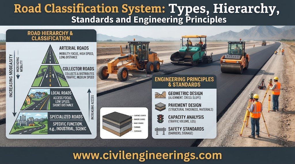
The central engineering concept is that roads perform different roles. A high-order highway primarily supports mobility, allowing people and freight to travel efficiently over longer distances. A local road emphasizes accessibility, providing direct access to homes, farms, businesses, schools, and other properties.
IRC guidance illustrates this functional approach by grouping non-urban roads into primary, secondary, and tertiary systems. Expressways and National Highways emphasize mobility, while lower-order district and village roads provide greater accessibility. State Highways and Major District Roads provide an intermediate connection between these functions.


Figure 1: Typical road classification hierarchy showing how traffic moves from local roads toward higher-order highways.
Functional Classification
Functional classification describes what a road is expected to accomplish within the overall network.
A commonly recognized hierarchy progresses through:
Expressway or Freeway → Arterial → Collector → Local Road
Higher-order facilities generally carry larger volumes of through traffic and connect important destinations. Lower-order roads primarily distribute traffic and provide direct access to properties.
The hierarchy is not merely theoretical. It affects how engineers manage intersections, roadside access, pedestrian movement, traffic speeds, pavement standards, and future development.
Administrative Classification
Administrative classification identifies the authority responsible for planning, funding, operating, or maintaining a road.
Depending on the country, roads may fall under:
- National government
- Provincial or state government
- District authorities
- Municipal authorities
- Local government
- Development authorities
- Special infrastructure agencies
Administrative and functional classifications should not be confused. A locally administered road may have considerable strategic importance, while a government-administered road may primarily provide local access.
Geographic Classification
Roads can also be grouped according to their physical and development environment.
Common categories include:
- Rural roads
- Urban roads
- Suburban roads
- Mountain roads
- Desert roads
- Coastal roads
- Industrial roads
- Agricultural roads
- Forest roads
Geographic classification is useful because terrain, land use, climate, drainage, and roadside activity can substantially change engineering requirements.
Why Is Road Classification Important?
Road classification is not simply a method of assigning names to roads. It influences engineering decisions throughout the life cycle of transportation infrastructure.
Establishing Road Hierarchy
A transportation network works more efficiently when each route has a defined role.
For example:
Local Roads → Collectors → Arterials → Highways → Expressways
This arrangement allows traffic to move progressively from property access toward high-capacity facilities.
Without an appropriate hierarchy, through traffic can enter residential streets, intersections can become overloaded, and major routes may experience unnecessary access conflicts.
Supporting Geometric Design
Classification helps engineers establish an appropriate design framework.
Depending on the road category, designers may assess:
- Design speed
- Lane width
- Shoulder width
- Median width
- Horizontal alignment
- Vertical alignment
- Stopping sight distance
- Superelevation
- Gradient
- Intersection spacing
- Access control
- Clear zones
A high-speed highway normally requires considerably more control over alignment, sight distance, roadside hazards, and access points than a low-speed local street.
Supporting Traffic Analysis
Road hierarchy provides an initial framework for traffic forecasting and capacity analysis.
One basic traffic indicator is Annual Average Daily Traffic:
AADT = Total annual traffic / 365
Where:
- AADT = Annual Average Daily Traffic
- Total annual traffic = traffic recorded over the year
For pavement design, engineers normally convert traffic into an appropriate design loading parameter based on the selected design methodology.
Guiding Infrastructure Investment
Road agencies have finite budgets. Classification can help establish priorities for:
- New road construction
- Road widening
- Pavement rehabilitation
- Bridge construction
- Drainage improvements
- Safety upgrades
- Intersection improvements
- Routine maintenance
A strategic highway connecting major economic centers may justify substantial investment because its failure can affect freight, commerce, emergency services, and regional mobility.
Improving Maintenance Planning
Road classification can also support maintenance programming.
A heavily trafficked arterial may require frequent pavement inspections because deterioration can quickly affect thousands of road users. A lightly trafficked local road may be managed through a different maintenance strategy based on traffic, climate, drainage, and available resources.
Major Types of Road Classification
Roads can be classified in several ways. There is no single worldwide classification table that applies identically to every country. National legislation, road authorities, and design standards establish their own systems.
From an engineering perspective, the most useful approaches include functional, administrative, geographic, traffic-based, and access-control classifications.
Freeways and Expressways
Freeways and expressways are high-standard facilities designed primarily for rapid and efficient movement.
Typical characteristics include:
- High design speeds
- Divided carriageways
- Controlled or limited access
- Grade-separated intersections
- Limited direct property access
- High geometric standards
- Strong roadside safety provisions
The major advantage is reduced conflict between through traffic and local access movements.
Arterial Roads
Arterials are major movement routes within an urban or regional network.
They commonly connect:
- Major urban districts
- Commercial centers
- Industrial areas
- Residential zones
- Transport terminals
- Other major highways
Arterials prioritize traffic movement but may also carry public transportation, pedestrians, and cyclists.
Collector Roads
Collector roads occupy the middle of the road hierarchy.
Their main function is to collect traffic from local roads and distribute it toward arterial roads.
A simplified network relationship is:
Local Roads → Collectors → Arterials → Regional Highways
Collectors therefore provide an important transition between property access and network mobility.
Local Roads
Local roads primarily provide direct access to properties and neighborhoods.
Examples include:
- Residential streets
- Neighborhood roads
- Small access roads
- Short industrial access routes
- Rural property access roads
Through traffic is generally not the primary purpose of these facilities.
Rural Road Classification
Rural road networks connect villages, towns, districts, agricultural areas, markets, regional centers, and major highways.
In the Indian context, IRC material identifies a hierarchy consisting of a Primary System, Secondary System, and Tertiary System. The primary system includes Expressways and National Highways. The secondary system includes State Highways and Major District Roads, while the tertiary system includes Other District Roads and Village Roads.


Figure 2: Typical rural road hierarchy connecting villages, districts, towns, regional centers, and major highways.
Expressways
Expressways provide high-speed movement with strong access control.
They may include:
- Divided carriageways
- Grade-separated interchanges
- Controlled entry and exit
- Service roads in selected locations
- Median safety barriers
- Emergency stopping facilities
- High-standard drainage
Because direct property access is restricted, expressways can maintain higher operational efficiency than roads with frequent junctions and driveways.
National Highways
National Highways form part of a country’s strategic transportation network.
They may connect:
- Major cities
- Ports
- Airports
- Economic centers
- State or provincial capitals
- Border crossings
- Industrial regions
Their exact geometric and pavement requirements depend on traffic, terrain, climate, development, and the applicable national standard.
State or Provincial Highways
State or provincial highways normally connect important destinations within a state or province.
They may connect:
- District headquarters
- Important towns
- Regional centers
- Economic areas
- National highways
They often provide a balance between regional mobility and local accessibility.
Major District Roads
Major District Roads provide important connections within districts and between major local centers.
They may carry significant quantities of:
- Agricultural traffic
- Commercial vehicles
- Passenger vehicles
- Public transportation
- Regional traffic
Traffic forecasts and economic activity should be considered when establishing their design requirements.
Other District Roads
Other District Roads provide connections between smaller settlements and local centers.
They may serve:
- Villages
- Farms
- Small markets
- Schools
- Local administrative facilities
- Other district routes
Their design standard is generally lower than that of major highways, although difficult terrain or high local traffic can justify improvements.
Village Roads
Village roads provide basic connectivity between rural communities and nearby facilities.
They can support access to:
- Schools
- Health facilities
- Markets
- Agricultural land
- Employment centers
- Public services
Their importance should not be judged only by traffic volume. A low-volume road can have substantial social and economic value for a rural community.
Urban Road Classification
Urban roads operate in a more complex environment because they must accommodate traffic movement while also serving pedestrians, cyclists, public transport, businesses, parking, property access, and public spaces.


Figure 3: Urban road hierarchy showing the different functions of arterials, collectors, and local streets.
Urban Expressways
Urban expressways provide high-capacity movement across metropolitan areas.
They generally emphasize:
- High capacity
- Controlled access
- Grade-separated interchanges
- Traffic management
- High operating speeds
- Strong safety systems
Because urban land is expensive and heavily developed, expressway planning can require extensive consideration of right-of-way, structures, environmental effects, and community impacts.
Urban Arterials
Urban arterials are major transportation corridors.
They may accommodate:
- Private vehicles
- Buses
- Freight
- Pedestrians
- Cyclists
- Emergency vehicles
A successful arterial design must balance movement with urban accessibility and roadside activity.
Urban Collectors
Collectors connect local streets to arterials.
They often carry more traffic than residential streets but less strategic traffic than major arterials.
Their design may need to accommodate:
- Local buses
- Pedestrian crossings
- Cycling facilities
- Driveways
- Parking controls
- Traffic-calming measures
Urban Local Roads
Local streets provide direct property access.
Typical examples include residential streets and neighborhood access roads.
Their design generally prioritizes:
- Low-speed movement
- Safety
- Property access
- Pedestrian comfort
- Community connectivity
Functional Classification: Mobility vs Accessibility
One of the most important concepts in modern road engineering is the relationship between mobility and accessibility.


Figure 4: Conceptual relationship between mobility and accessibility across the road hierarchy.
Mobility
Mobility describes the ability to move people and goods efficiently through a transportation network.
Higher-order facilities normally provide:
- Higher speeds
- Longer-distance travel
- Fewer interruptions
- Fewer access points
- Greater traffic capacity
Accessibility
Accessibility describes how easily people can reach destinations and properties.
Lower-order roads generally provide greater direct access.
The challenge for engineers is to create a network in which each facility performs an appropriate balance of these functions.
ICE guidance on highways and streets emphasizes the relationship between movement and place, reinforcing the idea that different roads should be planned according to their surroundings and intended purpose.
Road Classification and Design Speed
Design speed is closely related to road function, but classification alone should never determine the final value.
Engineers should also consider:
- Terrain
- Land use
- Roadside development
- Traffic composition
- Climate
- Safety
- Right-of-way constraints
- Intersection frequency
- Environmental conditions
A simplified stopping sight distance relationship is:
SSD = perception-reaction distance + braking distance
For a simplified level-road condition:
SSD = 0.278 Vt + V²/(254f)
Where:
- SSD = stopping sight distance in metres
- V = speed in km/h
- t = perception-reaction time in seconds
- f = coefficient of longitudinal friction
This equation is useful for understanding the engineering relationship between speed and sight distance. Final design values should always follow the applicable national or project-specific standard.


Figure 5: Typical geometric design elements influenced by road classification, design speed, terrain, and traffic conditions.
Horizontal Alignment
Higher-order roads generally require careful control of:
- Curve radius
- Transition curves
- Superelevation
- Sight distance
- Horizontal clearance
Vertical Alignment
Vertical geometry includes:
- Grades
- Crest curves
- Sag curves
- Vertical sight distance
- Drainage considerations
Steep terrain may require compromises between grade, curve geometry, earthwork quantities, and environmental impacts.
Road Classification and Pavement Design
Road classification influences pavement planning because road function often corresponds with traffic importance and expected loading.
Engineers may evaluate:
- Traffic volume
- Axle-load distribution
- Heavy commercial vehicles
- Design period
- Subgrade strength
- Climate
- Drainage
- Pavement materials
- Reliability
- Maintenance strategy
A major freight highway carrying substantial heavy-vehicle traffic will normally require a stronger pavement structure than a lightly trafficked residential road.
However, classification alone does not determine pavement thickness.
A simplified pavement design sequence is:
Traffic Loading → Subgrade → Climate → Materials → Reliability → Pavement Structure
Depending on project requirements, the final pavement may be flexible, rigid, or another engineered pavement system.


Figure 6: Typical pavement layer arrangement showing the relationship between the pavement structure and supporting subgrade.
Flexible Pavement
Flexible pavement commonly uses bituminous or asphalt layers over granular or stabilized layers.
Typical components may include:
- Wearing course
- Binder course
- Base course
- Subbase
- Compacted subgrade
Rigid Pavement
Rigid pavement generally uses a concrete slab as the primary structural layer.
Its design requires consideration of:
- Concrete strength
- Slab thickness
- Joint spacing
- Load transfer
- Subgrade support
- Temperature effects
- Drainage
The appropriate pavement type should result from engineering analysis rather than road classification alone.
Road Classification and Access Control
Access control is another important distinction between road categories.
Full Access Control
Typical of expressways and freeways.
Direct access from adjacent properties is normally prohibited.
Partial Access Control
Some major arterials and highways restrict certain access points while allowing controlled connections.
Open Access
Common on:
- Local roads
- Village roads
- Rural access roads
- Some lower-order highways
Frequent driveways and intersections can increase conflict points. Access management therefore becomes increasingly important as road function shifts toward mobility.
How Road Classification Affects Construction
Classification should be considered before detailed construction planning because it influences the quality and capacity expected from the completed facility.
Earthworks
Higher-order roads may require substantial:
- Cut excavation
- Embankment construction
- Ground improvement
- Slope stabilization
- Compaction
- Formation preparation
Drainage
Drainage design should reflect both environmental conditions and the importance of maintaining road service.
Typical facilities include:
- Side drains
- Median drains
- Cross-drainage structures
- Culverts
- Catchwater drains
- Outfalls
- Erosion protection
Poor drainage can accelerate pavement deterioration regardless of road class.
Pavement Construction
Construction quality should match the approved design.
Important quality-control checks include:
- Material quality
- Layer thickness
- Moisture content
- Density and compaction
- Surface levels
- Crossfall
- Smoothness
- Asphalt temperature where applicable
- Concrete strength where applicable
Road Safety
Road classification also affects the type and intensity of safety treatment.
Depending on the facility, engineers may specify:
- Signs
- Pavement markings
- Delineators
- Guardrails
- Median barriers
- Lighting
- Pedestrian crossings
- Traffic signals
- Grade-separated crossings
- Speed management measures
How to Determine the Correct Road Classification
Road classification should reflect the actual and intended role of the route rather than simply its existing name.
Step 1: Identify Network Function
Ask:
What does this road connect?
Determine whether it connects individual properties, neighborhoods, villages, towns, cities, industrial areas, ports, or major transportation corridors.
Step 2: Analyze Existing Traffic
Collect data such as:
- AADT
- Peak-hour traffic
- Vehicle classification
- Heavy-vehicle percentage
- Directional distribution
- Seasonal variation
Step 3: Study Access Conditions
Evaluate:
- Intersections
- Driveways
- Side roads
- Pedestrian crossings
- Bus stops
- Commercial accesses
Step 4: Evaluate Land Use
Determine whether the corridor passes through:
- Rural land
- Residential areas
- Commercial districts
- Industrial areas
- Mixed-use development
Step 5: Consider Future Development
Current traffic does not tell the entire story.
A road serving a planned industrial estate, airport, logistics center, or rapidly expanding urban area may require a higher functional classification than present-day traffic suggests.
Step 6: Review the Applicable Standard
The proposed classification should finally be checked against the requirements of the relevant road authority and design standard.
Road Classification Example
Consider a hypothetical transportation network connecting a village, district town, major city, and international freight terminal.
A possible hierarchy could be:
Village → Local Road → Collector → District Road → Arterial → National Highway → Expressway → Freight Terminal
Each road performs a different function.
The village road provides local access.
The collector gathers local traffic.
The district route connects regional destinations.
The arterial handles larger urban or regional traffic.
The National Highway provides strategic intercity movement.
The expressway supports controlled, high-speed travel toward the freight terminal.
This hierarchy avoids the unnecessary expense of designing every road to the highest highway standard.
Common Road Classification Mistakes
Incorrect classification can produce expensive design and operational problems.
Classifying Roads by Width Alone
A wide road is not automatically an arterial or highway. Function, connectivity, traffic, access, and context are more meaningful.
Using Traffic Volume as the Only Criterion
Traffic is important, but strategic importance and future demand also matter.
Ignoring Future Development
Land-use changes can transform traffic patterns rapidly.
Confusing Administrative and Functional Classification
The authority responsible for a road does not necessarily define its functional role.
Applying One Standard Everywhere
Urban, rural, mountainous, and environmentally constrained roads require context-sensitive decisions.
Ignoring Pedestrians and Cyclists
Urban classification should account for non-motorized transportation, particularly around schools, markets, public transport stops, and commercial areas.
Road Classification Standards: IRC, AASHTO and ICE
Road classification should always be interpreted within the standards applicable to the project location.
IRC
The Indian Roads Congress (IRC) publishes guidance covering road planning, geometric design, rural roads, pavement engineering, traffic engineering, and other highway disciplines.
IRC material describes a road hierarchy based on transportation function and includes systems such as Expressways, National Highways, State Highways, Major District Roads, Other District Roads, and Village Roads.
Engineers working on Indian projects should consult the latest applicable IRC publications rather than relying on outdated classification tables.
AASHTO
The American Association of State Highway and Transportation Officials (AASHTO) provides widely used guidance for geometric design through A Policy on Geometric Design of Highways and Streets, commonly known as the Green Book.
Its framework recognizes functional categories such as:
- Local roads and streets
- Collectors
- Arterials
- Freeways
AASHTO also considers context, including rural and urban environments, which demonstrates an important modern principle: road classification should reflect both transportation function and surrounding conditions.
ICE
The Institution of Civil Engineers (ICE) provides professional resources covering transportation planning, highways, road development, and infrastructure management.
ICE material emphasizes understanding the purpose of different roads and the relationship between movement and place.
These organizations provide valuable professional frameworks, but engineers must always verify the current edition and project-specific requirements before using a standard for final design.
The article continues below with the professional implementation guidance, FAQs, and conclusion.
Practical Recommendations for Civil Engineering Students
Students should learn road classification as a network concept, not simply as a list of road names.
Focus on:
- Functional hierarchy
- Mobility versus accessibility
- Traffic characteristics
- Geometric design
- Pavement engineering
- Access control
- Road safety
- Urban and rural context
- Drainage requirements
A useful study exercise is to select a familiar road network and classify each route.
For example:
Residential Street → Collector → Urban Arterial → Highway → Expressway
Then ask why each road has a different function.
Students should also practice reading road maps, traffic-count reports, typical cross-sections, highway drawings, and geometric design standards. This develops engineering judgment that cannot be gained through memorization alone.
Practical Recommendations for Highway Engineers and Consultants
Professional designers should verify classification during the planning stage rather than waiting until detailed design.
Recommended checks include:
- Confirm the network function.
- Review current traffic.
- Develop realistic traffic forecasts.
- Assess existing and future land use.
- Examine access requirements.
- Evaluate road safety.
- Consider pedestrians, cyclists, and public transport.
- Review terrain and environmental constraints.
- Coordinate classification with pavement and drainage design.
- Document the technical basis for the selected classification.
- Confirm the applicable national and project standards.
- Review whether the classification remains appropriate throughout the design horizon.
A classification decision should be traceable. A design report should explain why the selected category is appropriate instead of merely stating a road name.
Practical Recommendations for Contractors
Contractors may not establish the official road classification, but understanding the classification helps them interpret project requirements and construction priorities.
Particular attention should be given to:
- Approved drawings
- Typical road cross-sections
- Pavement layer specifications
- Drainage details
- Traffic management plans
- Temporary access arrangements
- Material testing
- Survey control
- Compaction requirements
- Road safety measures
- Quality assurance procedures
A contractor should not downgrade construction quality simply because existing traffic appears low. Contract documents, approved drawings, specifications, and engineer instructions determine the required construction standard.
Frequently Asked Questions About Road Classification System
What is a Road Classification System?
A Road Classification System is a method of categorizing roads according to their function, connectivity, traffic role, access characteristics, geographic setting, and sometimes administrative responsibility.
What are the main functional road classes?
A widely used functional hierarchy consists of freeways or expressways, arterials, collectors, and local roads. Individual countries may use different terminology or add additional categories.
Why is road classification important in highway engineering?
It helps engineers establish an appropriate framework for geometric design, traffic management, access control, pavement planning, safety treatment, maintenance, and investment.
What is the difference between an arterial and a collector road?
An arterial primarily supports movement between major destinations. A collector gathers traffic from local roads and transfers it toward arterials or other higher-order routes.
Are National Highways always the highest road category?
No. In some transportation systems, expressways or freeways operate above conventional National Highways because they provide stronger access control, higher design standards, and grade-separated intersections.
Does road width determine classification?
No. Width alone cannot determine functional classification. Engineers should also examine connectivity, traffic, access, land use, design speed, strategic importance, and future demand.
How does road classification affect pavement design?
Classification can provide an indication of the expected function and importance of a road, but pavement thickness must be determined using engineering inputs such as traffic loading, subgrade strength, climate, materials, design period, and the selected pavement design methodology.
Can a road classification change?
Yes. Roads may be upgraded, downgraded, or reclassified when traffic patterns, land use, strategic importance, network connectivity, or development conditions change.
Which standards should engineers use for road classification?
Engineers should use the standards adopted by the relevant road authority. Depending on the project, these may include IRC, AASHTO, national highway manuals, regional standards, or local road authority specifications.
Is road classification useful for maintenance planning?
Yes. Classification helps authorities prioritize inspection, routine maintenance, rehabilitation, emergency response, and funding according to the importance and service requirements of different routes.
Conclusion
A properly developed Road Classification System provides a foundation for an efficient, safe, and economical transportation network. It enables engineers to understand what each road should accomplish and prevents the common mistake of treating every route as though it has identical traffic, access, environmental, and design requirements.
The most effective approach is to view classification from a network perspective. Expressways and major highways generally emphasize mobility, while collectors and local roads provide progressively greater accessibility. Arterials and regional routes occupy an important middle ground where movement and access must be carefully balanced.
For engineering teams, classification should influence—but never independently dictate—geometric design, pavement engineering, drainage, traffic management, safety, and maintenance. Traffic forecasts, terrain, land use, climate, environmental constraints, and future development must also be considered.
IRC, AASHTO, ICE, and national highway authorities provide valuable professional frameworks. Nevertheless, the current standard adopted by the relevant road authority should govern final design decisions.
When classification is based on sound engineering judgment and realistic future network requirements, road infrastructure becomes safer, more functional, easier to maintain, and more cost-effective throughout its service life.

Kamran Malik is a passionate civil engineering writer and researcher who specializes in construction, transportation, structural engineering, and infrastructure topics. Through his articles on CivilEngineerings.com, he simplifies complex engineering concepts and shares practical insights, industry trends, and educational resources for students, professionals, and engineering enthusiasts.