
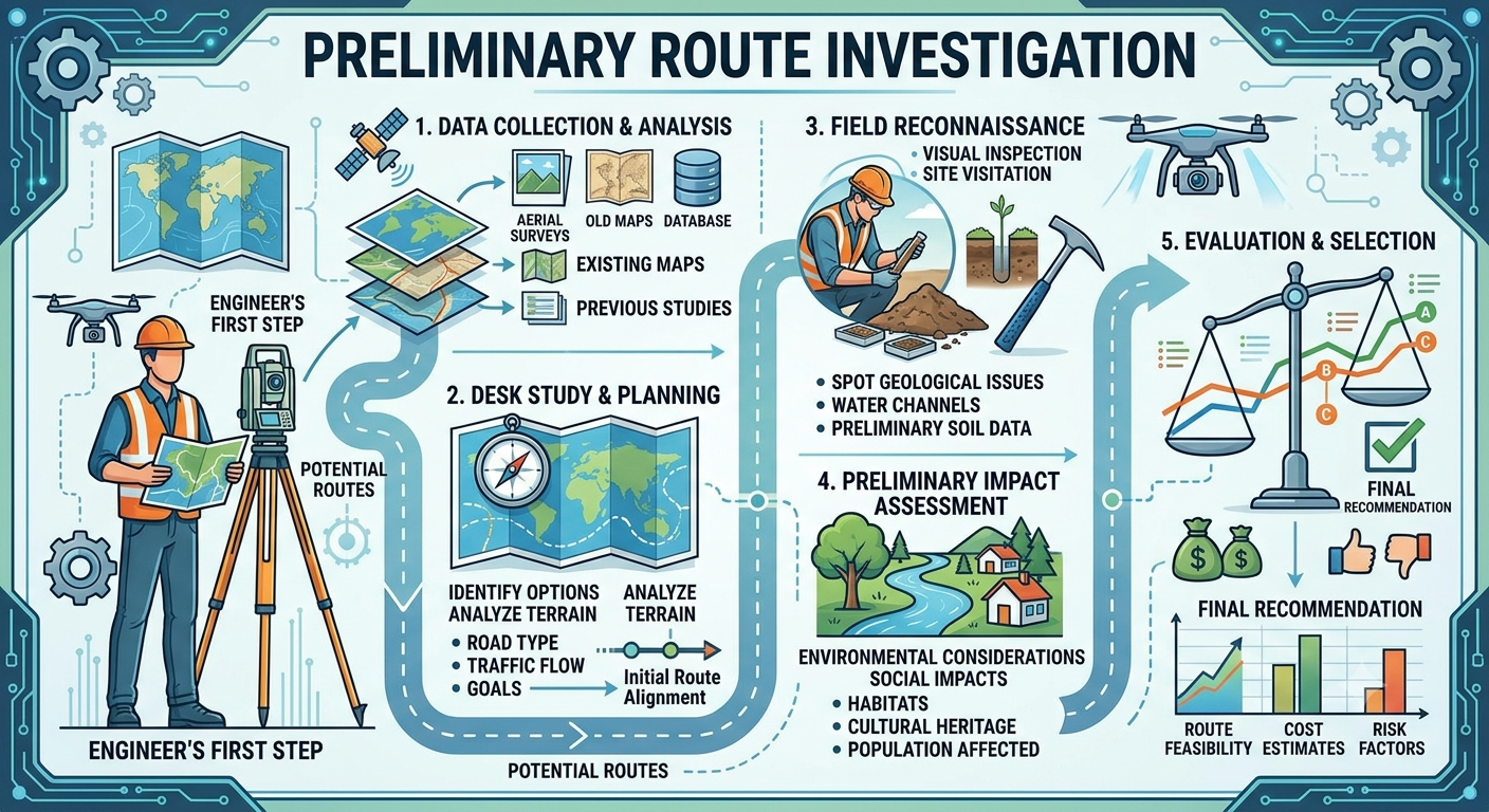
Preliminary Route Investigation
Selecting the right alignment is one of the most important decisions in any highway or road construction project. Before engineers prepare detailed designs or begin construction, they must carefully evaluate several possible routes to determine the safest, most economical, and environmentally suitable option. This process is known as Preliminary Route Investigation.
A well-executed preliminary route investigation minimizes construction risks, reduces project costs, improves road safety, and helps avoid future maintenance problems. It provides engineers with the technical information needed to compare alternative alignments and identify the most practical route based on terrain, geology, hydrology, environmental conditions, traffic demand, and land use.
Modern highway projects combine traditional field surveys with advanced technologies such as Geographic Information Systems (GIS), drone mapping, satellite imagery, LiDAR, and Global Navigation Satellite Systems (GNSS). These tools enable engineers to evaluate route alternatives more efficiently while improving the accuracy of planning decisions.
This guide explains the objectives, procedures, engineering principles, survey methods, and practical applications of Preliminary Route Investigation, making it a valuable resource for civil engineers, transportation professionals, contractors, and engineering students.
What Is Preliminary Route Investigation?
Preliminary Route Investigation is the systematic process of examining, comparing, and evaluating several possible road alignments before selecting the most suitable route for detailed engineering design.
The investigation focuses on collecting technical, environmental, economic, and social information that influences alignment selection. Instead of concentrating on a single route, engineers assess multiple alternatives to identify the option that offers the best balance between safety, constructability, environmental impact, and lifecycle cost.
The investigation serves as a bridge between the reconnaissance stage and the detailed design phase. Decisions made during this stage significantly influence the project’s construction cost, operational efficiency, and long-term performance.
Objectives of Preliminary Route Investigation
The primary goal is to identify the most practical highway alignment while minimizing engineering challenges and environmental impacts.
Specific objectives include:
- Compare multiple route alternatives objectively.
- Estimate construction and maintenance costs.
- Evaluate topography and terrain conditions.
- Identify rivers, valleys, hills, and existing infrastructure.
- Assess geological and soil characteristics.
- Study drainage patterns and flood-prone areas.
- Minimize environmental and social impacts.
- Improve road safety through better alignment selection.
- Reduce earthwork quantities wherever possible.
- Provide reliable information for detailed engineering surveys.
By achieving these objectives, engineers can avoid costly design changes during later project stages.
Importance of Preliminary Route Investigation
A road alignment influences nearly every aspect of a highway project, from construction costs to user safety. Choosing an unsuitable route may lead to excessive excavation, unstable slopes, poor drainage, or unnecessary environmental impacts.
A thorough preliminary investigation offers several advantages:
Reduces Project Costs
Evaluating alternative alignments allows engineers to identify routes that require less excavation, fewer bridges, and minimal land acquisition.
Improves Safety
Proper alignment selection reduces sharp curves, steep gradients, and limited sight distances, resulting in safer roadways.
Minimizes Environmental Impact
Careful planning helps avoid environmentally sensitive areas such as wetlands, forests, wildlife habitats, and protected landscapes.
Enhances Constructability
Routes that provide easier access, stable ground conditions, and favorable terrain simplify construction activities and reduce project delays.
Supports Sustainable Infrastructure
Modern transportation planning emphasizes sustainable development by balancing engineering requirements with environmental and community needs.
Stages of Highway Route Investigation
Route investigation generally follows a structured sequence. Each stage provides progressively more detailed information.
Project Need
      │
      ▼
Map Study
      │
      ▼
Reconnaissance Survey
      │
      ▼
Preliminary Survey
      │
      ▼
Alternative Route Evaluation
      │
      ▼
Final Location Survey
      │
      ▼
Detailed Design
1. Map Study
The map study is the initial desktop assessment of the project area.
Engineers analyze available maps and digital data to identify potential corridors before conducting field visits.
Information Reviewed
- Topographic maps
- Satellite imagery
- Land use maps
- Existing road network
- River systems
- Contour maps
- Utility corridors
- Administrative boundaries
Modern GIS software allows engineers to overlay multiple datasets, making route comparison more efficient.
Benefits
- Saves field investigation time.
- Eliminates impractical alignments early.
- Identifies potential engineering constraints.
- Supports preliminary cost estimation.
2. Reconnaissance Survey
The reconnaissance survey is a rapid field inspection conducted after the map study.
Its purpose is to verify map information and observe actual ground conditions.
During this stage, engineers visit several potential alignments rather than collecting detailed measurements.
Activities Performed
- Visual terrain assessment.
- Identification of natural obstacles.
- Observation of existing roads.
- Preliminary soil evaluation.
- River and drainage inspection.
- Bridge location assessment.
- Identification of settlements and public utilities.
Reconnaissance surveys help eliminate unsuitable routes before investing time and resources in detailed surveys.
3. Preliminary Survey
Once promising corridors have been identified, engineers conduct more detailed field investigations.
Typical tasks include:
- Topographic surveying.
- Soil sampling.
- Geological mapping.
- Hydrological analysis.
- Preliminary traffic studies.
- Cost estimation.
- Alignment comparison.
Data collected during this phase forms the basis for selecting the preferred route.
4. Final Location Survey
After selecting the preferred alignment, engineers carry out a detailed location survey.
This stage includes:
- Precise centerline surveying.
- Horizontal and vertical alignment design.
- Cross-section surveys.
- Benchmark establishment.
- Setting control points.
- Preparation of construction drawings.
The final location survey provides the information required for detailed engineering design and construction.
Planning Before the Investigation
Successful preliminary route investigations begin with careful planning.
Before entering the field, engineers should define the project scope, study available information, and organize resources.
Key Planning Activities
- Define project objectives.
- Review available maps and reports.
- Obtain satellite imagery.
- Prepare survey equipment.
- Develop safety procedures.
- Coordinate with local authorities.
- Identify environmental constraints.
- Schedule field investigations.
Proper planning improves survey efficiency and minimizes unnecessary fieldwork.
Data Collection Methods
Reliable engineering decisions depend on accurate data. Preliminary route investigations combine information from multiple sources to create a comprehensive understanding of the project area.
Topographic Information
Topography determines how easily a road can be constructed.
Important features include:
- Hills
- Valleys
- Slopes
- Ridges
- Rivers
- Existing infrastructure
Steep terrain often increases construction costs because it requires additional excavation, retaining structures, and drainage works.
Geological Investigation
Geological studies identify ground conditions that influence pavement performance and structural stability.
Engineers evaluate:
- Rock formations
- Soil types
- Fault zones
- Landslide-prone areas
- Groundwater conditions
Selecting a route through stable geological formations reduces future maintenance and repair costs.
Hydrological Study
Water significantly affects road performance.
Hydrological investigations assess:
- Rivers
- Streams
- Floodplains
- Surface runoff
- Drainage channels
- Seasonal water levels
Proper hydrological analysis helps determine the locations of bridges, culverts, and drainage structures while reducing flood risks.
Traffic Assessment
Projected traffic demand influences highway classification and geometric design.
Traffic studies evaluate:
- Existing traffic volumes.
- Vehicle composition.
- Future traffic growth.
- Freight movement.
- Regional connectivity.
Accurate traffic forecasting ensures that the selected alignment can accommodate future transportation needs.
Environmental and Social Considerations
Modern highway planning extends beyond engineering performance. Preliminary investigations also consider environmental protection and community impacts.
Factors commonly assessed include:
- Protected ecosystems
- Agricultural land
- Forest areas
- Cultural and historical sites
- Residential settlements
- Noise-sensitive zones
- Utility relocation requirements
Considering these factors early helps reduce environmental impacts, land acquisition issues, and project delays.
Reconnaissance Survey
The reconnaissance survey provides engineers with first-hand knowledge of the project area. Unlike detailed surveys, this stage emphasizes observation and comparison rather than precise measurements.
Objectives
- Verify information obtained during the map study.
- Examine terrain characteristics.
- Identify engineering challenges.
- Compare alternative corridors.
- Observe existing transportation facilities.
- Evaluate accessibility for construction equipment.
Equipment Commonly Used
- GPS/GNSS receivers
- Drones for aerial photography
- Digital cameras
- Handheld laser rangefinders
- Field notebooks
- Tablets with GIS applications
- Measuring wheels
- Compasses
Practical Example
Suppose engineers are planning a new two-lane highway between two towns separated by a hilly region. A map study identifies three possible corridors. During the reconnaissance survey, the team discovers that one route passes through unstable slopes, another requires multiple river crossings, and the third follows relatively gentle terrain with fewer environmental constraints. Based on these observations, the third corridor becomes the preferred option for detailed preliminary surveying.
This early evaluation saves considerable time and reduces the likelihood of expensive design modifications during later stages of the project.
Route Selection Criteria
After collecting field data, engineers evaluate each alternative alignment using technical, economic, environmental, and social factors. The objective is to identify a route that offers the best overall performance throughout its design life rather than simply choosing the shortest distance.
1. Terrain and Topography
Topography has a direct influence on road alignment, construction methods, and project cost.
Engineers assess:
- Ground slopes
- Hills and valleys
- Mountain passes
- Natural ridges
- Floodplains
Routes with moderate gradients generally require less earthwork, fewer retaining structures, and lower maintenance costs.
2. Geological Conditions
The stability of the underlying ground is a critical factor in route selection.
Preferred alignments avoid:
- Landslide-prone areas
- Expansive clay soils
- Weak foundation soils
- Fault zones
- Sinkholes
Stable geology reduces long-term maintenance requirements and enhances pavement performance.
3. Hydrology and Drainage
Water-related challenges significantly affect highway durability.
Engineers evaluate:
- River crossings
- Seasonal streams
- Flood-prone zones
- Groundwater levels
- Natural drainage patterns
Selecting routes with fewer major drainage crossings often lowers construction costs and simplifies maintenance.
4. Traffic Demand
Traffic projections influence the geometric design and future capacity of the highway.
Important considerations include:
- Present traffic volume
- Future growth forecasts
- Commercial vehicle percentage
- Regional connectivity
- Population growth
The selected alignment should accommodate projected traffic demand throughout its intended service life.
5. Environmental Considerations
Modern highway engineering prioritizes sustainable development.
Engineers seek to minimize impacts on:
- Forests
- Wetlands
- Wildlife habitats
- Agricultural land
- Protected ecosystems
- Water resources
Early environmental evaluation reduces approval delays and supports responsible infrastructure development.
6. Social and Economic Factors
Infrastructure projects affect surrounding communities as well as transportation systems.
Engineers consider:
- Land acquisition requirements
- Residential displacement
- Access to schools and hospitals
- Business impacts
- Utility relocation
- Future urban development
Balancing technical efficiency with community needs contributes to successful project implementation.
Engineering Principles Behind Preliminary Route Investigation
Effective Preliminary Route Investigation relies on established engineering principles that promote safety, durability, and cost efficiency.
Economy
The selected alignment should minimize total lifecycle costs rather than focusing only on initial construction expenses.
Safety
Road geometry should provide adequate sight distance, safe horizontal curves, appropriate gradients, and sufficient roadside clearance.
Constructability
Routes should be practical to build using available equipment, materials, and construction techniques.
Sustainability
Modern projects emphasize environmental protection, efficient resource use, and climate resilience.
Serviceability
The road should provide a comfortable, reliable, and efficient transportation corridor throughout its design life.
Practical Applications of Preliminary Route Investigation
The principles of preliminary route investigation are applied across a wide range of transportation projects.
National Highways
Highway agencies evaluate multiple corridors to improve regional connectivity while minimizing environmental impacts.
Rural Roads
Investigations identify economical routes that provide reliable access to villages, farms, and public services.
Expressways
Route studies focus on high-speed geometric standards, limited access, and long-term traffic growth.
Mountain Roads
Detailed investigations reduce risks associated with steep terrain, unstable slopes, and rockfalls.
Industrial Access Roads
Engineers select alignments capable of accommodating heavy commercial vehicles while minimizing operational costs.
Example of Route Comparison
Consider three possible alignments connecting two cities.
| Route | Advantages | Limitations |
|---|---|---|
| Route A | Shortest distance | Crosses steep hills and requires extensive earthwork |
| Route B | Stable terrain with moderate earthwork | Slightly longer alignment |
| Route C | Lowest environmental impact | Requires two major bridge crossings |
Although Route A is shorter, Route B may provide the lowest lifecycle cost due to easier construction and reduced maintenance requirements.
Simplified Route Investigation Process
Project Requirement
        │
        ▼
Map Study
        │
        ▼
Reconnaissance Survey
        │
        ▼
Preliminary Survey
        │
        ▼
Collect Technical Data
        │
        ▼
Compare Alternative Routes
        │
        ▼
Environmental & Economic Evaluation
        │
        ▼
Select Preferred Alignment
        │
        ▼
Final Location Survey
        │
        ▼
Detailed Design
This structured process helps engineers make informed decisions while reducing technical and financial risks.
Best Practices for Preliminary Route Investigation
Successful investigations require both technical expertise and careful planning.
Recommended best practices include:
- Begin with comprehensive map and GIS studies.
- Visit every potential alignment during field reconnaissance.
- Collect accurate topographic and geological data.
- Evaluate seasonal drainage conditions.
- Consider future traffic demand rather than current volumes alone.
- Document observations using photographs and digital mapping tools.
- Coordinate with environmental and local planning authorities.
- Compare alternatives using consistent evaluation criteria.
- Maintain complete field records for future reference.
- Review findings through multidisciplinary engineering teams.
Following these practices improves the reliability of alignment selection and supports efficient project delivery.
Practical Recommendations
Civil Engineers
- Integrate GIS, satellite imagery, and drone surveys with traditional field investigations.
- Validate desktop studies through on-site observations.
- Include climate resilience in route evaluation.
- Compare alternatives using technical, environmental, and economic criteria.
Contractors
- Participate in early site inspections to identify construction challenges.
- Review access routes for equipment and materials.
- Assess the availability of local construction resources.
- Highlight practical concerns before detailed design begins.
Engineering Students
- Learn the sequence of highway surveys and their objectives.
- Develop proficiency in reading contour maps and topographic plans.
- Study modern surveying technologies such as GPS, LiDAR, and GIS.
- Practice comparing alternative alignments through case studies and design exercises.
General IRC and AASHTO Considerations
Internationally recognized engineering organizations provide guidance for route investigation and highway planning.
IRC (Indian Roads Congress)
IRC publications discuss topics such as:
- Highway planning
- Route selection
- Geometric design
- Traffic surveys
- Drainage considerations
- Environmental aspects
- Pavement planning
These recommendations encourage safe, economical, and durable highway development while considering local conditions.
AASHTO (American Association of State Highway and Transportation Officials)
AASHTO guidance emphasizes:
- Functional highway classification
- Design consistency
- Safety performance
- Traffic forecasting
- Alignment design
- Terrain evaluation
- Long-term infrastructure sustainability
Although project-specific requirements vary by country, the principles promoted by IRC and AASHTO share a common goal of delivering safe, efficient, and reliable transportation networks.
Frequently Asked Questions (FAQs)
1. What is Preliminary Route Investigation?
Preliminary Route Investigation is the process of evaluating multiple highway alignment alternatives before selecting the most suitable route for detailed engineering design.
2. Why is Preliminary Route Investigation important?
It reduces construction costs, improves safety, minimizes environmental impacts, and helps engineers identify the most practical alignment before detailed design begins.
3. What are the main stages of route investigation?
The process generally includes map study, reconnaissance survey, preliminary survey, route evaluation, final location survey, and detailed engineering design.
4. Which factors influence route selection?
Engineers consider topography, geology, drainage, traffic demand, environmental constraints, land acquisition, construction feasibility, and long-term maintenance requirements.
5. What technologies are commonly used during Preliminary Route Investigation?
Modern investigations use GIS, GPS/GNSS, drones, LiDAR, satellite imagery, digital terrain models, and conventional surveying equipment to collect accurate field data.
6. How does Preliminary Route Investigation reduce project costs?
By comparing alternative alignments early, engineers can avoid unstable ground, reduce earthwork, minimize bridge construction, and limit land acquisition, resulting in lower lifecycle costs.
7. What is the difference between a reconnaissance survey and a preliminary survey?
A reconnaissance survey is a rapid field inspection used to identify feasible corridors, while a preliminary survey gathers detailed engineering data for comparing alternative alignments.
Conclusion
A successful Preliminary Route Investigation establishes the technical foundation for every highway project. By systematically studying terrain, geology, drainage, traffic demand, environmental constraints, and socioeconomic factors, engineers can identify the alignment that offers the best balance of safety, constructability, sustainability, and long-term value. Careful investigation at this stage reduces design revisions, controls construction costs, and improves the overall performance of the completed roadway.
Advances in technologies such as GIS, drone surveying, LiDAR, and satellite imagery have significantly enhanced the accuracy and efficiency of route investigations. However, these tools complement rather than replace sound engineering judgment and thorough field verification. By following proven practices and applying the general principles outlined by IRC and AASHTO, transportation professionals can carry out a Preliminary Route Investigation that supports resilient, economical, and future-ready road infrastructure for generations to come.

Kamran Malik is a passionate civil engineering writer and researcher who specializes in construction, transportation, structural engineering, and infrastructure topics. Through his articles on CivilEngineerings.com, he simplifies complex engineering concepts and shares practical insights, industry trends, and educational resources for students, professionals, and engineering enthusiasts.