
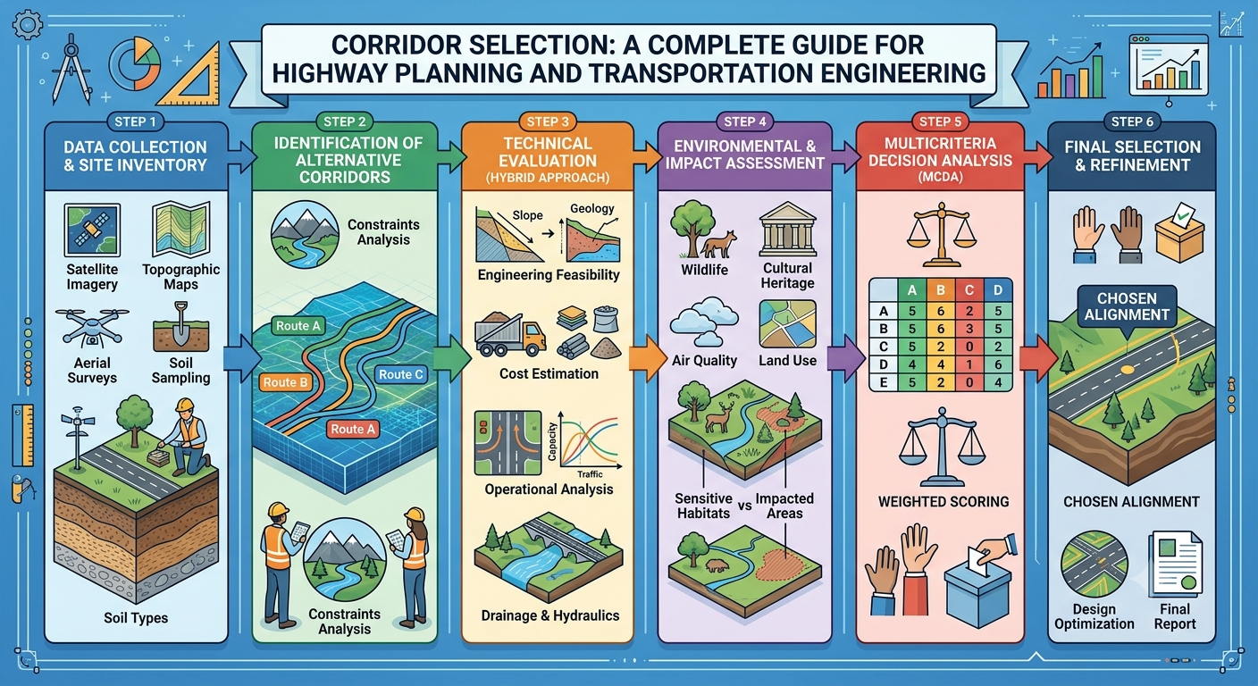
Corridor Selection
Selecting the right transportation corridor is one of the most important decisions made during the planning of a highway, expressway, railway, or other linear infrastructure project. Before engineers prepare detailed designs or begin construction, they must determine the most suitable route that balances technical feasibility, environmental sustainability, economic efficiency, and public interest. This critical planning activity is known as Corridor Selection.
A well-chosen corridor reduces construction costs, minimizes environmental impacts, improves traffic efficiency, and provides long-term benefits for communities and businesses. On the other hand, selecting an unsuitable corridor can lead to expensive land acquisition, construction delays, environmental conflicts, and increased maintenance costs throughout the project’s lifecycle.
Whether you are a civil engineer, transportation planner, contractor, or engineering student, understanding the principles of Corridor Selection is essential for developing safe, sustainable, and cost-effective transportation infrastructure. This guide explains the concept, objectives, engineering principles, influencing factors, and the step-by-step corridor selection process used in modern highway engineering.
What Is Corridor Selection?
Corridor Selection is the process of identifying and evaluating potential routes for transportation infrastructure before selecting the most suitable alignment for detailed design and construction.
A transportation corridor is a broad strip of land within which the final road, highway, railway, or utility alignment will eventually be located. Instead of choosing a single centerline at the beginning of a project, engineers first study several corridors to determine which one best satisfies engineering, environmental, economic, and social requirements.
The corridor selection stage is completed before detailed highway alignment design. It serves as a bridge between project planning and engineering design, ensuring that the selected route is practical, safe, and sustainable.
Practical Example
Suppose a government plans to connect two cities separated by rivers, agricultural land, and hilly terrain. Rather than selecting the shortest route immediately, engineers identify three or four possible corridors. Each option is evaluated based on construction cost, environmental impacts, land acquisition, traffic demand, and long-term performance. The most suitable corridor is then chosen for detailed engineering design.
Why Corridor Selection Is Important
The corridor selected during the planning phase influences almost every aspect of the project, including construction cost, travel efficiency, environmental impact, maintenance requirements, and public acceptance.
Poor corridor selection can result in:
- Excessive earthwork
- Unstable slopes
- Flooding issues
- High land acquisition costs
- Increased bridge construction
- Environmental objections
- Community displacement
- Construction delays
Conversely, a carefully selected corridor provides numerous benefits:
- Improved road safety
- Reduced construction costs
- Better traffic flow
- Lower maintenance expenses
- Shorter travel times
- Enhanced regional connectivity
- Reduced environmental disturbance
Because of these long-term implications, corridor selection is considered one of the most critical stages of transportation planning.
Objectives of Corridor Selection
The primary goal of Corridor Selection is to identify the route that offers the best balance between engineering performance, environmental protection, and economic viability.
Specific objectives include:
- Providing safe and efficient transportation.
- Minimizing construction and maintenance costs.
- Reducing travel distance and travel time.
- Avoiding environmentally sensitive areas.
- Minimizing land acquisition requirements.
- Preserving natural resources where possible.
- Supporting future traffic growth.
- Improving regional economic development.
- Enhancing accessibility between communities.
- Ensuring long-term infrastructure sustainability.
These objectives often compete with one another, requiring engineers to evaluate trade-offs before making a final recommendation.
Factors Affecting Corridor Selection
Selecting an appropriate corridor requires evaluating numerous technical and non-technical factors. No single factor determines the final decision; instead, engineers analyze how different considerations interact.
Topography
Terrain strongly influences construction complexity and project cost.
Engineers generally prefer corridors that:
- Minimize steep slopes
- Reduce excavation and embankment work
- Avoid unstable hillsides
- Simplify drainage design
Flat terrain often requires less earthwork, while mountainous regions may increase construction costs because of tunnels, retaining structures, or extensive cut-and-fill operations.
Geology and Soil Conditions
The strength and stability of the underlying soil directly affect pavement performance and structural safety.
Geotechnical investigations help identify:
- Weak subgrade soils
- Expansive clays
- Soft deposits
- Rock formations
- Landslide-prone areas
- Groundwater conditions
Choosing a corridor with favorable ground conditions can significantly reduce foundation costs and improve long-term durability.
Traffic Demand
Transportation corridors should satisfy both present and future travel requirements.
Traffic studies evaluate:
- Average Daily Traffic (ADT)
- Peak-hour traffic
- Freight movement
- Population growth
- Industrial development
- Tourism demand
A corridor that adequately accommodates projected traffic growth minimizes future congestion and costly expansions.
Environmental Considerations
Environmental sustainability has become a major factor in modern infrastructure planning.
Corridors should avoid or minimize impacts on:
- Forests
- Wetlands
- Wildlife habitats
- Rivers
- Protected areas
- Agricultural land
- Water resources
Where avoidance is not possible, mitigation measures such as wildlife crossings, reforestation, and erosion control may be incorporated into the project.
Social and Economic Factors
Transportation projects affect communities as well as the environment.
Engineers evaluate:
- Residential areas
- Schools
- Hospitals
- Cultural heritage sites
- Religious places
- Business districts
- Future urban expansion
The preferred corridor should improve accessibility while minimizing displacement and social disruption.
Existing Infrastructure
Integrating new infrastructure with existing transportation networks improves efficiency and reduces construction costs.
Existing infrastructure includes:
- Highways
- Railways
- Airports
- Utility corridors
- Bridges
- Industrial zones
Utilizing or paralleling existing corridors may reduce environmental impacts and simplify future maintenance.
Corridor Selection Process
Although every project differs, transportation agencies generally follow a structured approach to corridor selection.
Step 1: Identifying the Transportation Need
Every project begins by identifying a transportation problem or opportunity.
Typical reasons include:
- Increasing traffic congestion
- Economic development
- Population growth
- Freight demand
- Safety improvements
- Regional connectivity
Transportation planners assess whether a new corridor is necessary or whether upgrading existing infrastructure would provide a more cost-effective solution.
Step 2: Collecting Existing Data
The next stage involves gathering all available information related to the project area.
Important data sources include:
- Topographic maps
- Satellite imagery
- Land use maps
- Geological maps
- Traffic studies
- Environmental databases
- Floodplain information
- Utility records
Modern Geographic Information Systems (GIS), drone surveys, and remote sensing technologies have greatly improved the efficiency and accuracy of this process.
Step 3: Preliminary Corridor Identification
Using the collected information, engineers identify several broad corridor alternatives.
Each corridor should be technically feasible and capable of meeting the project’s objectives.
At this stage, only broad route options are developed rather than detailed highway alignments.
Typical considerations include:
- Terrain
- Major river crossings
- Urban areas
- Protected land
- Existing road network
- Future development plans
Step 4: Reconnaissance Survey
Field investigations verify whether the proposed corridors are practical.
Engineering teams visit each corridor to observe actual site conditions that may not be visible on maps or satellite imagery.
The reconnaissance survey typically examines:
- Ground conditions
- Existing drainage
- Vegetation
- Rock outcrops
- Access roads
- Utility conflicts
- Settlement patterns
These observations often lead to modifications before detailed evaluations begin.
Step 5: Developing Alternative Corridors
After reconnaissance, engineers refine the corridor options into realistic alternatives suitable for comparative analysis.
Each alternative should include preliminary information on:
- Corridor length
- Estimated construction cost
- Earthwork quantities
- Bridge requirements
- Environmental impacts
- Land acquisition needs
- Traffic performance
Developing multiple alternatives allows decision-makers to compare technical performance and overall project value before selecting the preferred corridor.
Engineering Principles of Corridor Selection
Several core engineering principles guide the corridor selection process:
- Balance construction cost with operational efficiency.
- Minimize environmental and social impacts.
- Design for future traffic growth rather than current demand alone.
- Ensure geometric safety and driver comfort.
- Reduce lifecycle maintenance costs.
- Optimize drainage and flood resilience.
- Consider long-term regional development plans.
- Integrate sustainable engineering practices wherever feasible.
Successful corridor selection requires interdisciplinary collaboration among transportation engineers, geotechnical specialists, environmental scientists, surveyors, economists, and urban planners.
Simple Corridor Selection Flow Diagram
Transportation Need
         │
         ▼
Data Collection
         │
         ▼
GIS & Map Analysis
         │
         ▼
Identify Possible Corridors
         │
         ▼
Reconnaissance Survey
         │
         ▼
Develop Alternative Corridors
         │
         ▼
Detailed Evaluation
         │
         ▼
Preferred Corridor Selection
Corridor Evaluation Methods
After developing several feasible corridor alternatives, engineers evaluate each option using technical, economic, environmental, and social criteria. The objective is to identify the corridor that provides the greatest overall benefit while minimizing risks and long-term costs.
Modern transportation agencies rely on systematic evaluation methods rather than selecting a route based solely on construction cost or distance.
Multi-Criteria Decision Analysis (MCDA)
One of the most widely used techniques is Multi-Criteria Decision Analysis (MCDA). This method compares each corridor against a set of weighted criteria, allowing planners to make transparent and objective decisions.
Typical evaluation criteria include:
- Construction cost
- Traffic performance
- Environmental impact
- Land acquisition requirements
- Public acceptance
- Road safety
- Geotechnical suitability
- Future expansion potential
- Maintenance requirements
- Economic benefits
Each criterion is assigned a weight according to project priorities. Engineers then score every corridor, and the alternative with the highest overall rating becomes the preferred option.
Cost-Benefit Analysis (CBA)
Cost-Benefit Analysis compares the expected economic benefits of a corridor with the total project cost.
Benefits commonly include:
- Reduced travel time
- Lower vehicle operating costs
- Fewer traffic accidents
- Increased regional trade
- Employment generation
- Improved accessibility
A corridor with higher long-term economic returns may be selected even if its initial construction cost is slightly higher.
Geographic Information System (GIS) Analysis
GIS has transformed corridor selection by allowing engineers to analyze large datasets simultaneously.
GIS can evaluate:
- Terrain and elevation
- Land use
- Soil conditions
- Population density
- Flood-prone areas
- Protected forests
- Existing infrastructure
- Utility corridors
Using GIS improves planning accuracy and significantly reduces the time required for preliminary evaluations.
Environmental and Social Considerations
Modern infrastructure projects must balance engineering objectives with environmental protection and community well-being.
A corridor that appears technically ideal may not be suitable if it causes unacceptable environmental or social impacts.
Environmental Considerations
Engineers seek to minimize impacts on:
- National parks
- Wildlife habitats
- Wetlands
- Rivers and lakes
- Forest reserves
- Agricultural land
- Air quality
- Water resources
Where impacts cannot be avoided, mitigation measures such as wildlife crossings, sediment control systems, noise barriers, and reforestation programs should be incorporated into the project.
Social Considerations
Transportation corridors influence people’s lives in many ways.
Important social factors include:
- Residential displacement
- Access to schools and hospitals
- Cultural heritage sites
- Religious places
- Business activities
- Community connectivity
- Public safety
Public consultation is often conducted during the planning stage to gather feedback and address community concerns before finalizing the corridor.
Practical Applications of Corridor Selection
The principles of Corridor Selection are applied across a wide range of transportation and infrastructure projects.
Highways and Expressways
Selecting a corridor that minimizes sharp curves, steep gradients, and unnecessary river crossings improves safety while reducing construction and maintenance costs.
Railways
Railway corridors require gentle gradients and large-radius curves to support safe and efficient train operations.
Urban Transportation
Cities use corridor selection when planning:
- Ring roads
- Bus Rapid Transit (BRT) systems
- Metro rail projects
- Elevated expressways
Utility Infrastructure
The same principles are applied to:
- Oil and gas pipelines
- Transmission lines
- Water supply systems
- Fiber optic networks
Engineering Example
Imagine three possible corridors connecting two rapidly growing cities.
A is the shortest route but passes through densely populated areas, requiring extensive land acquisition and relocation.
B is slightly longer but follows gently rolling terrain, avoids major settlements, and requires fewer bridges.
C avoids urban areas but crosses environmentally sensitive wetlands and unstable soil.
After evaluating construction costs, environmental impacts, traffic performance, land acquisition, and long-term maintenance, engineers may select Corridor B because it provides the best balance between technical feasibility, sustainability, and lifecycle cost.
This example illustrates why the shortest route is not always the best engineering solution.
Best Practices for Corridor Selection
Successful transportation projects follow several proven best practices during corridor planning:
- Begin planning with clearly defined transportation objectives.
- Collect accurate and up-to-date survey data.
- Use GIS and remote sensing for preliminary analysis.
- Conduct detailed geotechnical investigations before finalizing the corridor.
- Consider future traffic growth rather than current demand alone.
- Minimize impacts on environmentally sensitive areas.
- Engage stakeholders and local communities early.
- Evaluate multiple corridor alternatives objectively.
- Perform comprehensive risk assessments.
- Document all assumptions and evaluation criteria for transparency.
Common Mistakes to Avoid
Even experienced project teams can encounter problems if the planning process is not carried out thoroughly.
Avoid these common mistakes:
- Relying on outdated traffic data.
- Ignoring geotechnical constraints.
- Underestimating environmental impacts.
- Selecting the shortest route without considering lifecycle costs.
- Overlooking future urban expansion.
- Inadequate stakeholder consultation.
- Insufficient field reconnaissance.
- Failing to compare multiple corridor alternatives.
- Ignoring drainage and flood risks.
- Making decisions based solely on initial construction costs.
Practical Recommendations
Civil Engineers
- Integrate traffic, geotechnical, environmental, and economic analyses from the beginning of the project.
- Validate GIS findings with field investigations.
- Prioritize lifecycle performance over minimum construction cost.
- Maintain clear documentation throughout the planning process.
Contractors
- Understand the selected corridor before preparing construction plans.
- Identify access challenges early.
- Coordinate with utility agencies during mobilization.
- Implement environmental protection measures during construction.
Engineering Students
- Learn how corridor planning differs from detailed highway alignment design.
- Develop skills in GIS, surveying, and transportation planning.
- Study case histories of successful highway projects.
- Understand how engineering, environmental, and economic factors interact during decision-making.
General Discussion of IRC, AASHTO, and ICE Practices
Recognized highway engineering organizations such as the Indian Roads Congress (IRC), the American Association of State Highway and Transportation Officials (AASHTO), and the Institution of Civil Engineers (ICE) emphasize a systematic and evidence-based approach to corridor planning.
Although specific design standards differ between countries, their guidance generally promotes:
- Comprehensive traffic forecasting.
- Reliable topographic and geotechnical investigations.
- Objective comparison of multiple corridor alternatives.
- Integration of environmental and social considerations.
- Safe geometric design principles.
- Sustainable infrastructure development.
- Effective drainage planning.
- Quality assurance throughout the planning and design process.
Following these widely accepted engineering principles helps create transportation corridors that are safe, durable, economical, and environmentally responsible.
Frequently Asked Questions (FAQs)
1. What is Corridor Selection in highway engineering?
Corridor Selection is the process of identifying, analyzing, and comparing potential routes to determine the most suitable corridor for transportation infrastructure before detailed alignment design begins.
2. Why is Corridor Selection important?
It reduces construction costs, improves road safety, minimizes environmental impacts, supports future traffic growth, and enhances the long-term performance of transportation projects.
3. What is the difference between corridor selection and alignment selection?
Corridor selection identifies a broad route where infrastructure may be developed, while alignment selection determines the exact centerline within the chosen corridor.
4. Which factors influence corridor selection?
Important factors include topography, geology, soil conditions, traffic demand, land use, environmental impacts, social considerations, drainage, and construction costs.
5. How does GIS improve corridor selection?
GIS enables engineers to analyze terrain, land use, environmental constraints, and infrastructure data efficiently, improving the accuracy and speed of corridor evaluations.
6. Why are environmental studies required during corridor selection?
Environmental studies help protect ecosystems, reduce ecological damage, support regulatory approvals, and ensure sustainable project development.
7. What role do geotechnical investigations play?
They identify soil and rock conditions that influence pavement design, foundation stability, earthwork requirements, and construction feasibility.
8. Can the shortest corridor be the best option?
Not always. A slightly longer corridor may provide lower construction costs, reduced environmental impacts, improved safety, and lower maintenance over its service life.
9. Who participates in the corridor selection process?
Transportation engineers, civil engineers, geotechnical specialists, environmental scientists, surveyors, economists, urban planners, and government agencies all contribute to the process.
10. Which standards provide guidance for corridor planning?
Highway agencies commonly follow nationally adopted standards and good engineering practices. General guidance from organizations such as IRC, AASHTO, and ICE supports systematic planning, objective evaluation, and sustainable infrastructure development.
Conclusion
Corridor Selection is one of the most influential stages in the planning of highways and other transportation infrastructure because it shapes every phase that follows, from detailed design and land acquisition to construction and long-term maintenance. A carefully selected corridor balances engineering feasibility, economic efficiency, environmental stewardship, and community needs rather than focusing on a single factor such as the shortest distance or lowest initial cost. By combining accurate surveys, geotechnical investigations, traffic analysis, GIS technology, environmental assessments, and structured evaluation methods, engineers can identify solutions that provide lasting value.
Adopting recognized engineering practices and engaging stakeholders early also helps reduce project risks, improve public acceptance, and support sustainable development. Whether you are an engineer designing a new highway, a contractor preparing for construction, or a student learning transportation engineering, mastering Corridor Selection is fundamental to delivering safe, resilient, and cost-effective infrastructure that meets both current transportation demands and future growth.

Kamran Malik is a passionate civil engineering writer and researcher who specializes in construction, transportation, structural engineering, and infrastructure topics. Through his articles on CivilEngineerings.com, he simplifies complex engineering concepts and shares practical insights, industry trends, and educational resources for students, professionals, and engineering enthusiasts.
Seks is breed beschikbaar op speciale platforms voor volwassenen. Kies voor betrouwbare adult hubs voor
veiligheid.
My blog post BUY XANAX WITHOUT PRESCRITION